
ISC Class 12 Geography Specimen Paper 2024 Download PDF
ISC Class 12 Geography Specimen Paper 2024 has been released by the CISCE. Students can download the ISC Class 12 Geography Specimen Paper 2024 PDF here.
ISC Class 12 Geography Specimen Paper 2024: The ISC Class 12 Geography Specimen Paper 2024 for the academic year 2023–2024 has been released by CISCE. The specimen papers for the remaining disciplines of the ISC class 12 exam, including geography, have also been made available on the Council for the Indian School Certificate Examinations' official website.
The updated format and question type for the ISC (Indian School Certificate) Class 12 Geography Specimen Paper 2024 will be based on the most recent syllabus. As a result, reading the sample document that the Council issued is crucial. To get high exam scores, students need to practise the questions found in the ISC Specimen Paper.ISC Class 12 Geography Specimen Paper 2024 Overview
For students planning to take the board exam in the upcoming 2023–2024 session, the official ISC Class 12 Geography Specimen Paper 2024 is now available. The specimen paper was made available to students several months in advance of the test, allowing them to thoroughly rehearse and get top scores. The most recent question formats and the revised exam design are included in the specimen paper.ISC Class 12 Exam Pattern 2023-24
A significant component of the ISC Class 12 Arts stream is geography. There are a range of question types on the ISC Class 12 Geography test paper, from theoretical to map based. The question is constructed in a way that assesses the candidate's analytical and memory skills. The ISC Class 12 Geography test paper is broken up into three portions to accommodate different kinds of questions.ISC Class 12 Geography Specimen Paper 2023-24 PDF
A well-thought-out preparation method that incorporates case study analysis, mapping exercises, and frequent revision can help you succeed on the ISC board test. These goals can be attained by methodically practicing the geography specimen paper. We are providing students with the PDF for the ISC Class 12 Geography Specimen Paper 2023-24 below in order to help with this.ISC Class 12 Geography Specimen Paper 2023-24 PDF
ISC Class 12 Geography Specimen Paper 2024 Key Points
The ISC Class 12 Geography exam carries a total of 70 marks. The ISC Geography Class 12 Specimen Paper 2024 states that the three-hour exam will be in geography. Below is a summary of some of the key points from the ISC Class 12 Geography test.- Maximum Marks: 70 Marks
- Time Limit of the Exam: 3 hours
- Time allocated for Reading the Paper: Additional 15 Minutes
- Number of Sections: 3
- Sections Name: A, B, and C
- Section A Marks: 14 Marks
- Section B Marks: 28 Marks
- Section C Marks: 28 Marks
ISC Class 12 Geography Specimen Paper 2024
The ISC Class 12 Geography Specimen Paper 2024 is meant to assess students on a broad range of geographic subjects. Along with factual knowledge, the article aims to evaluate the ability to analyse geographic patterns, processes, and issues ranging from physical geography to human geography. The following is a list of some of the key guidelines provided in the ISC Geography Class 12 Specimen paper 2024.- Respond to each and every question in Sections A, B, and C.
- Very brief answer and objective questions comprise Section A.
- There are short answer questions in Section B.
- Long answer questions are found in Section C.
- The marks each question carries are given in the bracket.
Importance of ISC Class 12 Geography Specimen Paper 2024
Completing the ISC Class 12 Geography Specimen Paper can help you score higher on the test. Examining the Specimen Paper will help students achieve significantly higher grades. Students receive a thorough understanding of the format, grading scheme, and types of questions that they might expect on the test. By becoming familiar with the paper's format and subject content, students can prioritise their themes, better manage their time, and modify their study schedules. Additionally, this will enable educators to properly arrange the geography curriculum.ISC Class 12 Geography Specimen Paper 2024 Section A
Note: Section A consists of 14 marks
Question 1 - (i) On the given outline Map of India, mark and label the following: (a) The mountain Range that starts from Delhi and ends in Gujarat. (b) The northern part of the Eastern Coastal Plains of India. (c) The strait between India and Sri Lanka. (ii) Refer to the given outline Map of India and identify the following: [3] (a) The north terminal of the ‘North-South Corridor’ marked D is __________. (b) The Sorrow of Bihar marked E is ______________. (c) The highest wheat producing state in India marked is __________.- Refer to the given outline map of India, identify the correct option and write it in the answer booklet provided.
ISC Class 12 Geography Specimen Paper 2024 Section B
Note: Section B consists of 28 marks
Question 3 (i) Briefly discuss any two methods to conserve fish as a resource. [2] (ii) Mention any two requirements of a planning region that Haldia port and its hinterland possess. [2] Question 4 (i) The total forest area of India is 24·39%. Suggest any two methods to increase the ‘area under forest’ in India. [2] (ii) Briefly explain why the ‘area sown more than once’ is low in India. [2] Question 5 Thousands of villagers living along the Arvari River in Rajasthan have set up three thousand johads under Arvari Pani Sansad. They are able to grow two crops a year instead of cultivating one dry crop. (i) Mention another such programme of water conservation which is in Andhra Pradesh. How is this programme beneficial? [2] (ii) Which modern method of irrigation for judicious use of water is most suitable for the state mentioned in the passage? Why? [2] Question 6 Observe any one of the images given below and answer the questions that follow.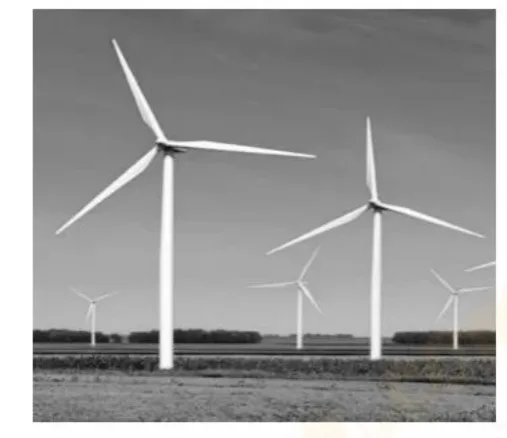 (i) (a)
Why is the energy generated by the above source considered important? [2]
(b) Give any two differences between the thermal power and the energy source shown above. [2]
OR
(ii) (a) [2]
Why is the metal shown above an important component in the electrical and electronic industry?
(b) What is the cause for the fall in demand for this metal in the world market? [2]
Question 7
(i) (a)
Why is the energy generated by the above source considered important? [2]
(b) Give any two differences between the thermal power and the energy source shown above. [2]
OR
(ii) (a) [2]
Why is the metal shown above an important component in the electrical and electronic industry?
(b) What is the cause for the fall in demand for this metal in the world market? [2]
Question 7
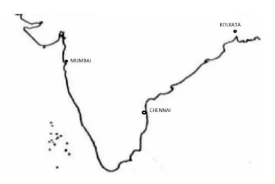 Roads and railways have connected the three ports in India as shown in the map given above.
How did this connectivity influence industrialisation in pre independent India?
Question 8 (i) Briefly discuss each of the following problems associated with the Green Revolution
(a) Regional disparities in economic development [2]
(b) Rise of unemployment in India [2]
OR
(ii) Briefly discuss each of the following major challenges of rice production in India
(a) Economic condition of the farmers [2]
(b) Small and fragmented farms [2]
Question 9
(i) India’s location at the head of Indian Ocean is significant.
State two points in support of this statement. [2]
(ii) Explain the geological formation of Peninsular Plateau. [2]
Roads and railways have connected the three ports in India as shown in the map given above.
How did this connectivity influence industrialisation in pre independent India?
Question 8 (i) Briefly discuss each of the following problems associated with the Green Revolution
(a) Regional disparities in economic development [2]
(b) Rise of unemployment in India [2]
OR
(ii) Briefly discuss each of the following major challenges of rice production in India
(a) Economic condition of the farmers [2]
(b) Small and fragmented farms [2]
Question 9
(i) India’s location at the head of Indian Ocean is significant.
State two points in support of this statement. [2]
(ii) Explain the geological formation of Peninsular Plateau. [2]
ISC Class 12 Geography Specimen Paper 2024 Section C
Note: Section C consists of 28 marks
Question 10 (i) Discuss the factors that influence temperature variations in different regions of India. [4] (ii) What factors have contributed to the growing demand for forest conservation in the country? [3] OR (i) What are the ways in which the westerly disturbance affects the climate in India? [3] (ii) Explain the Chipko movement and give the reasons for its success. [4] Question 11 Study the sketch map given below and answer the questions that follow. (i) Identify the landform A in the sketch map given above. Describe any two advantages of this landform’s location and extent. [3] (ii) Name any two drainage systems of India influenced by the location of this landform A. How would the absence of this landform impact the drainage systems and water distribution in India? [4] Question 12 (i) The National Capital Region (NCR) in India is one of the largest and most populous urban agglomeration in the country. It includes the capital city of Delhi along with several surrounding urban areas, such as Gurugram, Noida, Ghaziabad, and Faridabad. [3] What is an urban agglomeration? How has rapid urbanisation increased the challenges faced by the above-mentioned urban agglomeration? (ii) Briefly discuss any two rural settlement types and any two of their characteristics. [4] Question 13 Read the passage given below and answer the questions that follow. According to a recent report of the Directorate of Economics and Statistics in the Union Ministry of Agriculture and farmers welfare, Maharashtra has outperformed Uttar Pradesh in sugar production. It has become the largest sugar-producing state in the country. Maharashtra has been maximising production by its better management of resources, proper utilisation of the mills’ crushing capacity and enhanced recovery rate. Source (edited): Times of India, Nov 7, 2022 (i) Briefly discuss any four reasons for the progress of the state, mentioned above, in sugar production. [4] (ii) How can climate impact sugar production in India? [3]ISC Preparation Tips
- The CISCE has revised the Class 12 syllabus this year. As a result, students need to review the entire curriculum for every subject.
- Only consult the literature that the CISCE board has recommended. In addition to the required readings, assess your level of preparedness by using past ISC sample papers from 2024.
- Take detailed notes by hand on every subject. This will come in very handy when it comes to revising.
- Don't omit any subject. Keep in mind that each topic is significant and that you can ask questions about any section of the syllabus.
- Before the ISC 12th Date Sheet 2024 is announced, finish the syllabus in order to allow enough time for revision.
ISC Class 12 Geography Specimen Paper 2024 FAQs
Will ISC 2024 be tough?
CISCE is going to increase questions that require understanding and critical thinking in ICSE and ISC Exams 2024.
What is the passing marks for ISC class 12 2024?
candidates are required to score a minimum of 35% in each subject to pass the ISC Class 12 Board Exam 2024.
What is top 4 rule in ISC?
ISC selects the best four subjects out of the six subjects. There are 5 groups in which the marks of Literature and English are combined and calculated out of 100. Out of the rest 4 subjects, 3 subjects are selected in accordance with the highest mark obtained, basically the best 3 out of 4.
🔥 Trending Blogs
Talk to a counsellorHave doubts? Our support team will be happy to assist you!

Join 15 Million students on the app today!

Free Learning Resources
PW Books
Notes (Class 10-12)
PW Study Materials
Notes (Class 6-9)
Ncert Solutions
Govt Exams
Our Other Websites
Class 6th to 12th Online Courses
Govt Job Exams Courses
UPSC Coaching
Defence Exam Coaching
Gate Exam Coaching
Other Exams
Know about Physics Wallah
Physics Wallah is an Indian edtech platform that provides accessible & comprehensive learning experiences to students from Class 6th to postgraduate level. We also provide extensive NCERT solutions, sample paper, NEET, JEE Mains, BITSAT previous year papers & more such resources to students. Physics Wallah also caters to over 3.5 million registered students and over 78 lakh+ Youtube subscribers with 4.8 rating on its app.
We Stand Out because
We provide students with intensive courses with India’s qualified & experienced faculties & mentors. PW strives to make the learning experience comprehensive and accessible for students of all sections of society. We believe in empowering every single student who couldn't dream of a good career in engineering and medical field earlier.
Our Key Focus Areas
Physics Wallah's main focus is to make the learning experience as economical as possible for all students. With our affordable courses like Lakshya, Udaan and Arjuna and many others, we have been able to provide a platform for lakhs of aspirants. From providing Chemistry, Maths, Physics formula to giving e-books of eminent authors like RD Sharma, RS Aggarwal and Lakhmir Singh, PW focuses on every single student's need for preparation.
What Makes Us Different
Physics Wallah strives to develop a comprehensive pedagogical structure for students, where they get a state-of-the-art learning experience with study material and resources. Apart from catering students preparing for JEE Mains and NEET, PW also provides study material for each state board like Uttar Pradesh, Bihar, and others
Copyright © 2026 Physicswallah Limited All rights reserved.