

Great Nicobar Project: Key Features, Strategic Importance, Environmental Issues, & PYQs

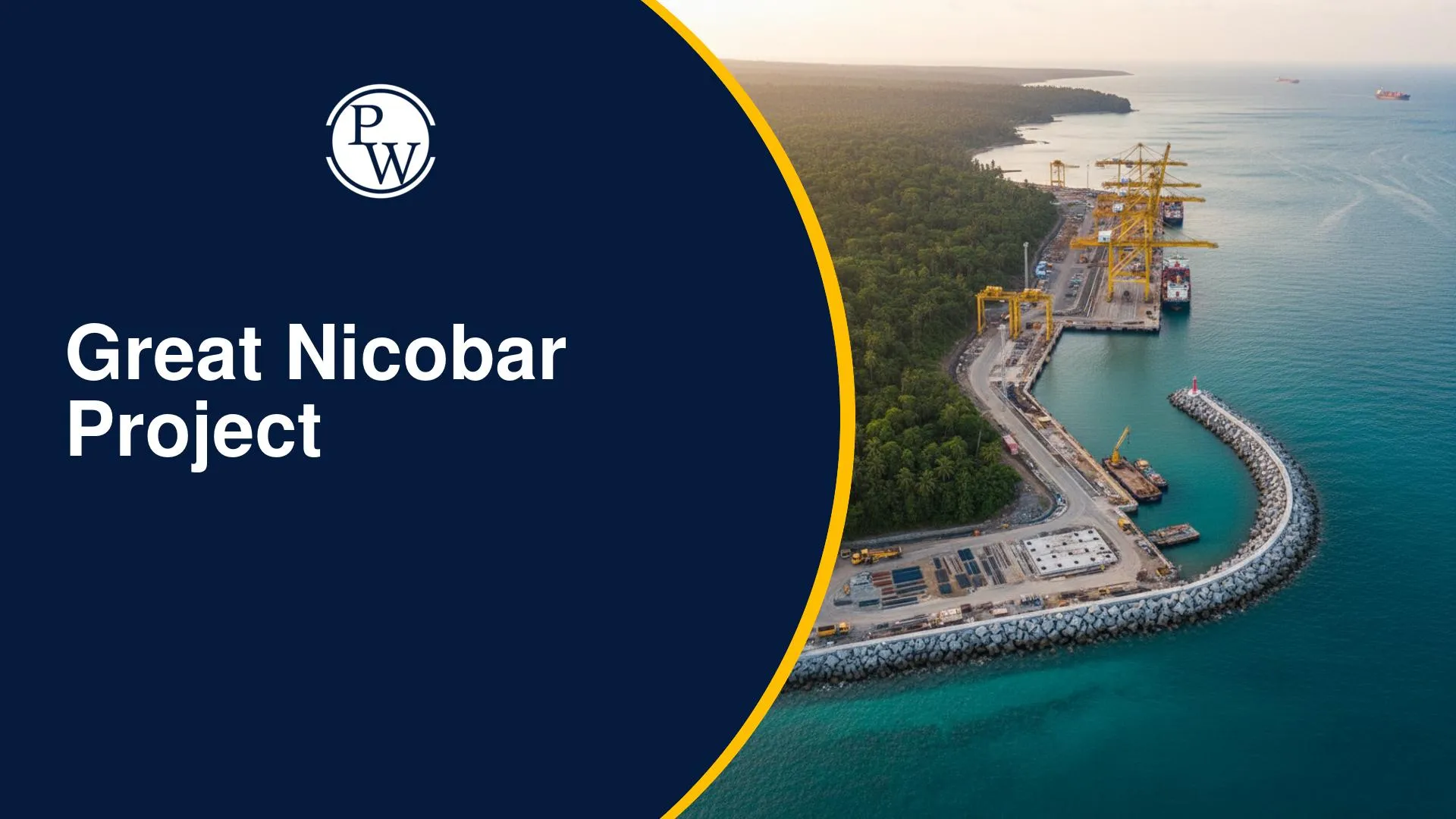
The Great Nicobar Project is a large-scale infrastructure initiative planned on Great Nicobar Island, which is the southernmost part of India. It includes a transshipment port, an international airport, a township, and a power plant. The project aims to improve connectivity, trade, and strategic presence in the Indo-Pacific region. At the same time, it has created debate between development needs and environmental protection.
The topic of the Great Nicobar Project is important from the perspective of the UPSC IAS Examination, falling under General Studies Paper I (Geography), General Studies Paper III (Environment & Internal Security), and Prelims.
UPSC Previous Year Questions and Practice QuestionsQ. Which of the following is geographically closest to Great Nicobar? (Prelims 2017)
Answer: (a) Sumatra Great Nicobar lies to the south of the Nicobar Islands of India. It is the largest island in the Nicobar group, and Sumatra lies to its south. |
What is the Great Nicobar Project?
The Great Nicobar Project is a multi-component development plan under the Island Development Programme led by NITI Aayog. It is designed to transform the island into a key node in global maritime trade and regional connectivity. Key components of the Great Nicobar Island project include:
-
International Container Transshipment Terminal (ICTT) at Galathea Bay, with a capacity of 14.2 million TEU
-
Greenfield International Airport has a capacity of 4000 Peak Hour Passengers (PHP)
-
A 450 MVA gas and solar-based power plant
-
A planned township spread over 16,610 hectares
The project is part of a broader Andaman Nicobar infrastructure project focused on integrated island development.
Key Features of the Project
The project has several important features that define its scale and purpose.
-
Large investment size: The project involves a significant investment of around ₹72,000 crore
-
Multi-phase development: It is planned in different phases over several years
-
Strategic location: The island is close to major global shipping routes near the Malacca Strait
-
Integrated development: Includes port, airport, energy, and urban infrastructure
-
Deep water advantage: The Galathea Bay transhipment port has natural deep water suitable for large ships
-
Trade potential: The transshipment port India Nicobar can help reduce dependence on foreign ports
Strategic Importance of the Great Nicobar Project
The project has strong strategic value for India due to its location and objectives.
-
Proximity to shipping routes: Close to one of the busiest sea lanes in the world
-
Maritime security: Strengthens India’s presence in the Indian Ocean Region
-
Defence advantage: Helps monitor movement near the Malacca Strait
-
Countering regional influence: Supports India’s position in the Indo-Pacific region
-
Act East Policy support: Improves links with Southeast Asian countries
-
Strategic importance of Nicobar Islands: Enhances India’s role as a regional maritime power
Environmental Concerns and Ecological Impact of Project
The project is located in a highly sensitive ecological region with rich biodiversity and dense forest cover. Due to this, the environmental impact Nicobar project has been widely discussed in policy and academic circles.
-
Impact on tropical rainforests: The project involves the diversion of 1.82% of the total forest cover of the Andaman and Nicobar Islands. These forests are part of a dense tropical ecosystem that supports diverse plant and animal life.
-
Threat to biodiversity (endemic species): The island is home to several endemic species that are not found anywhere else. Large-scale construction and land use changes may disturb their natural habitat.
-
Impact on coral reefs and coastal ecosystems: Development of the Galathea Bay transhipment port and related activities may affect nearby coral reefs and coastal systems, which are important for marine biodiversity.
-
Concerns over leatherback turtle habitat: Great Nicobar Island is known for nesting sites of leatherback turtles. Increased human activity and infrastructure development may impact these breeding grounds.
-
Deforestation and ecological imbalance: Around 18.65 lakh trees are estimated in the project area, with up to 7.11 lakh trees expected to be felled in phases. Although 65.99 sq. km is kept as a green zone and compensatory afforestation is planned over 97.30 sq. km, concerns remain about long-term ecological balance.
Tribal Impact and Social Issues in the Great Nicobar Project
The island is home to vulnerable tribal communities, making social safeguards important in the Nicobar mega project in India.
-
Tribal Population:
-
Shompen tribe (around 237 individuals)
-
Nicobarese community (around 1,094 individuals)
-
No Displacement Policy: No relocation proposed for tribal communities
-
Tribal Reserve Impact:
-
Total tribal reserve: 751.070 sq. km
-
84.10 sq. km overlaps with the project area
-
73.07 sq. km effectively de-notified
-
Compensation Measure:
-
76.98 sq. km re-notified as tribal reserve
-
Net increase of 3.912 sq. km
-
Policy Alignment: Based on the Shompen Policy (2015) and the Jarawa Policy (2004)
-
Monitoring Mechanism: Dedicated committee for tribal welfare
Economic Benefits of the Great Nicobar Project for Indi
The project is expected to support economic development in the region.
-
Boost to trade: The port can handle large cargo and improve logistics
-
Reduced dependency: Less reliance on foreign transshipment hubs
-
Employment generation: Opportunities in construction, services, and logistics
-
Tourism growth: Better connectivity can attract visitors
-
Infrastructure expansion: Development of roads, housing, and utilities
-
Regional development: Supports long-term growth of the island economy
Major Challenges in the Great Nicobar Project Implementation
The project faces several structural and operational challenges that may affect its execution and outcomes.
-
Environmental clearance controversies: Concerns have been raised over forest diversion, biodiversity impact, and approvals in an ecologically sensitive region.
-
Seismic vulnerability (earthquake-prone zone): Great Nicobar lies in a high-risk seismic and tsunami-prone area, increasing infrastructure risk.
-
High financial cost: The project requires a large investment, which adds pressure on long-term economic viability.
-
Implementation challenges: Remote location, logistical difficulties, and coordination among multiple agencies may slow execution.
Government Measures & Safeguards
The project includes multiple safeguards to manage environmental and social risks.
-
Environmental Impact Assessment (EIA): Approved under EIA 2006 and ICRZ 2019 with 42 conditions covering pollution, biodiversity, and disaster management.
-
Compensatory afforestation: Around 97.30 sq. km of land has been identified in Haryana for plantation, along with tree plantation initiatives on the islands.
-
Wildlife conservation plans: Studies by ZSI, WII, SACON, and IISc guide the protection of biodiversity, marine ecosystems, and species like turtles.
-
Monitoring mechanisms: Separate committees for pollution, biodiversity, and tribal welfare, with an overarching body for coordination and compliance.
Way Forward: Balancing Development and Sustainability
A balanced approach is needed to ensure development without harming the island’s ecology and communities.
-
Balance between development and ecology: Development should follow the phased plan and remain within ecological limits, like the 1.82% forest diversion and protected green zones.
-
Sustainable infrastructure planning: Use low-impact construction and expand renewable energy, building on the gas–solar power model.
-
Strong environmental safeguards: Strict implementation of EIA conditions and continuous monitoring of forests, marine life, and biodiversity is essential.
-
Tribal rights protection: Ensure no displacement of Shompen and Nicobarese communities and proper implementation of tribal reserve re-notification.
-
Transparent governance: Maintain clear coordination, monitoring, and public communication through oversight committees.