Siliguri Corridor: Location, Strategic Importance, Challenges, Security Measures

Siliguri Corridor is a narrow stretch of land in India that connects the northeastern states with the rest of the country. It is also termed the “Chicken’s Neck” because of its thin shape. This corridor is very important for India’s security, trade, and communication.
The Siliguri Corridor is surrounded by several countries, making it strategically significant. Any disruption in this area can affect the movement of people, goods, and the military.
What is Siliguri Corridor?
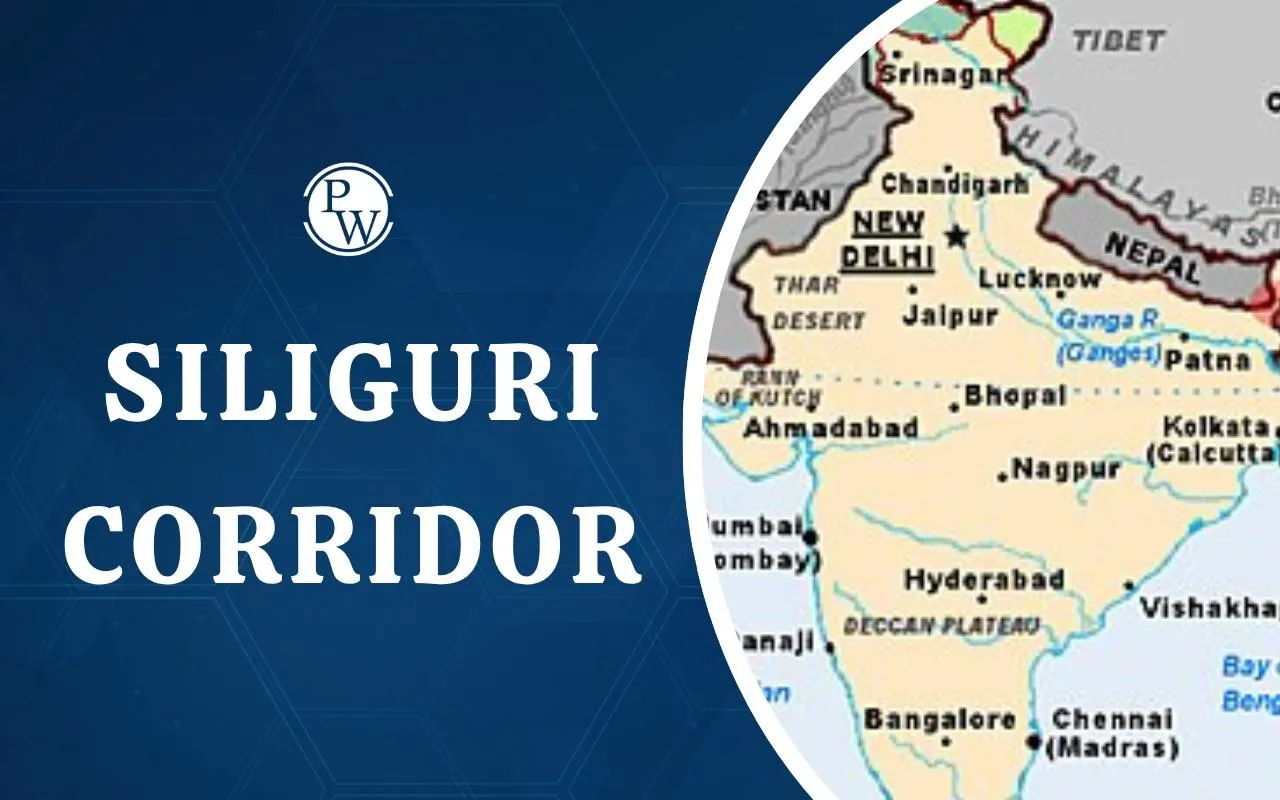
The Siliguri Corridor Chicken Neck is located in the northern part of West Bengal. It connects the northeastern states of India with the mainland. The Siliguri Corridor is very narrow. Its geography and location make the region strategically sensitive. Any road or railway in this corridor is important for trade and transport between the northeastern states and the Indian mainland. Certain important points related to the location of the Siliguri Corridor are as follows:
-
Width: Approximately 20-22 kilometres at its narrowest point.
-
Length: About 200 kilometres connecting West Bengal to Assam and other northeastern states.
-
Surrounding countries: Nepal, Bhutan, and Bangladesh.
-
Nearby rivers: The Teesta and Mahananda rivers pass through the region.
-
Terrain: Mix of plains, forests, and small hills.
-
Climate: Subtropical with heavy rainfall during the monsoon season.
-
Significance: It acts as the only land route for connecting India to its northeastern region.
History and Background of Siliguri Corridor
Siliguri Corridor, the Chicken Neck of India, has been significant for many decades due to its location between India and neighbouring countries. Its strategic importance increased after India gained independence. During the 1962 Sino-Indian War, the narrow corridor highlighted India’s vulnerability in connecting with the northeastern states.
-
During British India, the region served as a gateway to the northeastern territories.
-
After 1947, the corridor became the only land link to India’s northeastern states.
-
India’s independence and partition made the corridor strategically sensitive.
-
Several border disputes with China, Nepal, Bhutan, and Bangladesh added to its importance.
-
The corridor has witnessed military and political planning to secure India’s northeastern region.
Siliguri Corridor Chicken Neck
The Siliguri Corridor is one of the most important regions in terms of India’s security and defence. The location and the narrow Siliguri Corridor Road make it significant for both transportation and military operations. The reason why Siliguri Corridor is called Chicken’s Neck is that the term reflects how a small stretch of land carries huge strategic significance for India’s defence.
-
Defence route: Allows the army to move quickly between northeast India and mainland India.
-
Vulnerable point: Its narrow width makes it a potential target in conflicts.
-
Border monitoring: Helps control activities near Nepal, Bhutan, and Bangladesh.
-
Military logistics: Supplies, troops, and equipment are transported through this corridor.
-
Geopolitical significance: The Siliguri Corridor Map is instrumental in keeping India connected with its northeastern states despite the surrounding international borders.
Challenges and Threats for Siliguri Corridor
The Siliguri Corridor also faces several challenges and threats that affect its safety and usefulness. The region’s narrow shape, location near international borders, and weak infrastructure make it sensitive to both natural and human-made problems.
Such issues and challenges slow down transport and trade while also creating risks for India’s national security. Managing these challenges is important to keeping the region stable and connected to the rest of the country. Some of the major challenges are as follows:
-
Narrow width: Limited space makes it difficult to expand roads or railways.
-
Natural hazards: Floods, landslides, and heavy rainfall can disrupt movement.
-
Security threats: Proximity to international borders increases risk from illegal crossings or infiltration.
-
Political tension: Border disputes with neighbouring countries can create instability.
-
Infrastructure limitations: Single highways and railway lines create bottlenecks for trade and military transport.
Siliguri Corridor Defence and Security Measures
Due to its strategic location, the Indian government has taken several measures to protect the Chicken Neck of India. The Government sees to it that the Rapid deployment of troops during natural disasters can be ensured, so that there is uninterrupted connectivity and protection of citizens.
-
Military presence: Army and paramilitary forces are stationed to safeguard the corridor.
-
Border infrastructure: Fences, observation posts, and checkposts are set up along borders.
-
Road and rail upgrades: Strengthening transport routes for rapid troop movement.
-
Disaster preparedness: Measures to deal with floods, landslides, and other natural hazards.
-
Surveillance systems: Cameras, drones, and radar monitoring enhance security.
-
Coordination with neighbours: Agreements with Bhutan, Nepal, and Bangladesh for peaceful border management.
The Siliguri Corridor is a small and narrow region, but an extremely important part of India. Its strategic location makes it significant for defence, trade, and communication with the northeastern states. It is a lifeline for the northeast, linking it with the rest of India.
Siliguri Corridor FAQs
What is the Siliguri Corridor?
Where is the Siliguri Corridor Chicken Neck located?
Why is the Siliguri Corridor strategically important for India?
What challenges does the Siliguri Corridor face?