Latitude and Longitude - Definition, Examples, and Facts
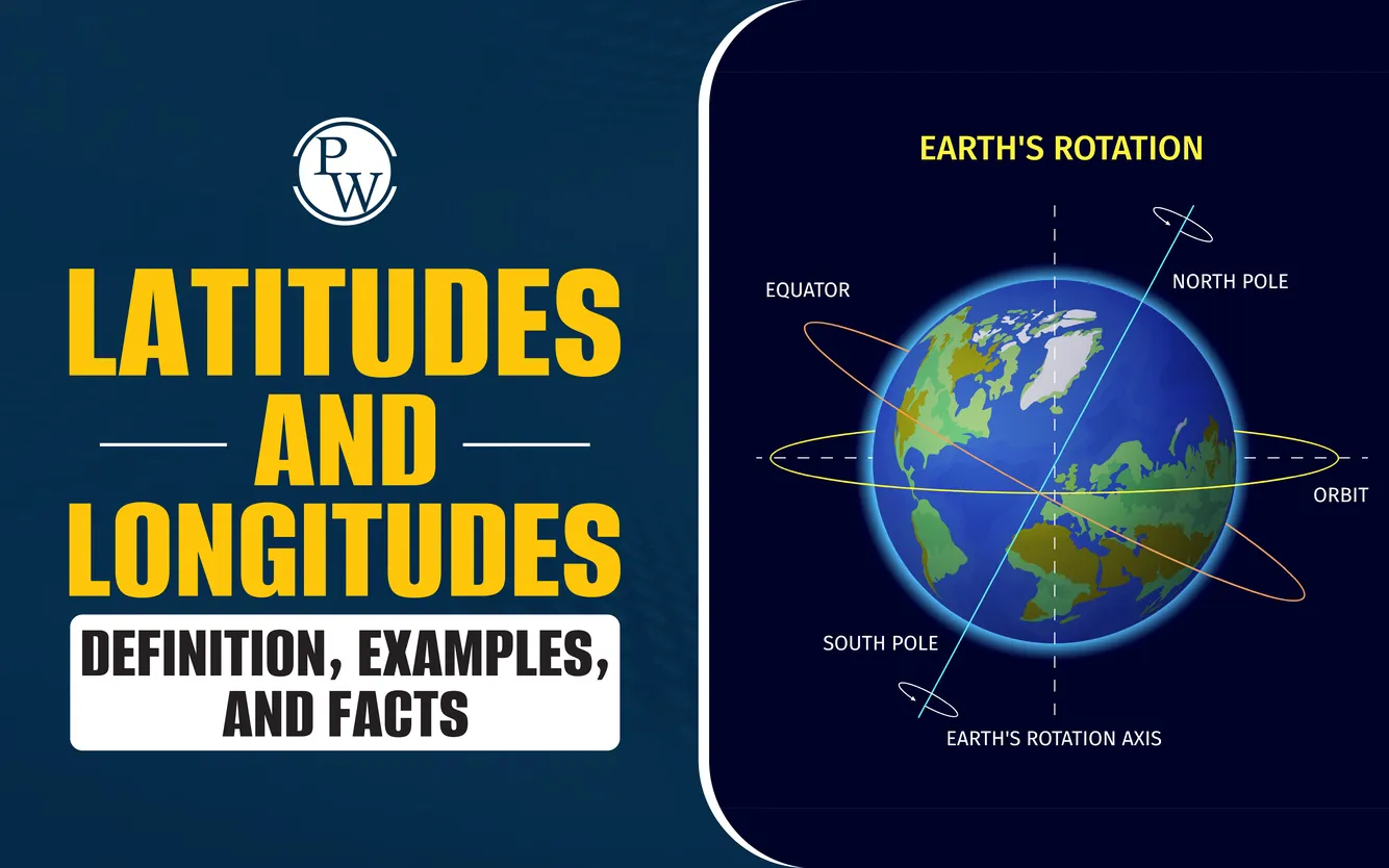

The Earth is a round planet filled with many wonderful places like countries, oceans, mountains, and cities. To help us find these places on a map or globe, we use special imaginary lines called latitudes and longitudes.
These lines form a grid that helps people know exactly where something is on Earth. With the help of this grid, we can find locations, understand time zones, follow the weather, and use apps to guide us. In this blog, we will learn latitudes and longitudes in detail.
Read More: Solar system
What Are Latitudes and Longitudes?
Latitudes and longitudes are imaginary lines drawn on maps and globes to help us find the exact location of any place on Earth. These lines work like a special address system for our planet. Just like your home has a street name and number, every place on Earth can be found using its latitude and longitude.
Latitude lines run across the Earth from east to west, while longitude lines run from the North Pole to the South Pole. Together, they form a grid. This grid helps us know where countries, cities, oceans, and even tiny islands are located.
Without latitudes and longitudes, it would be very hard to find anything on a map. Scientists, travelers, and even smartphone apps use these lines to help us explore and understand the world better.

What is Latitude?
Latitude is how far a place is from the Equator (an imaginary line that goes around the middle of the Earth). Lines of latitude go from left to right (east to west) like stripes on a watermelon. The Equator is called 0° latitude, and it's the starting point.
There are 90 lines of latitude to the north (called north latitude) and 90 lines to the south (called south latitude). So, latitudes range from 0° to 90° N or 0° to 90° S.
Some special latitudes are:
-
Equator (0°)
-
Tropic of Cancer (23.5°N)
-
Tropic of Capricorn (23.5°S)
-
Arctic Circle (66.5°N)
-
Antarctic Circle (66.5°S)
-
North Pole (90°N)
-
South Pole (90°S)
What is Longitude?
Longitude is how far a place is from the Prime Meridian. The Prime Meridian is a line that goes from the North Pole to the South Pole through Greenwich, England. It is marked as 0° longitude.
Lines of longitude go up and down (north to south). They help us know how far a place is to the east or west of the Prime Meridian. There are 180 lines of longitude to the east and 180 lines to the west. These are called east longitude and west longitude.
Together, lines of latitude and longitude help us find any place on Earth.
Read More: Three States of Matter
How Do We Use Latitudes and Longitudes?
Let’s say you want to find a place on a map. Maybe your friend is in another country and you want to know where they are. You can use their latitude and longitude to locate them.
Think of it like a big game of “X marks the spot.” The point where a line of latitude crosses a line of longitude gives us the exact location. This point is written as (Latitude, Longitude).
For example,
The location of Delhi, India is (28.6° N, 77.2° E).
How to Find Location by Latitude and Longitude?
There are several ways to find a location by latitude and longitude:
-
Using a globe or map: You can follow the horizontal (latitude) and vertical (longitude) lines until they meet. That’s the place!
-
Using a phone or GPS: Just enter the numbers, and your device will show you the place on a map.
-
Using a website or app: There are free tools where you type in the coordinates, and it shows you the exact spot.
What is the Use of Latitude and Longitude?
Latitude and longitude help people all around the world understand where places are. These invisible lines on the globe are not just for maps, they are used in real life every single day. Let’s explore how they are useful:
-
Navigation: Airplanes, ships, and even cars use latitudes and longitudes to travel safely.
-
Weather: Scientists use them to track storms, rain, and other weather events.
-
Time: They help set local time zones based on how far a place is from the Prime Meridian
-
Addressing: Some apps can convert latitude and longitude to address. This is called reverse geocoding.
-
Exploration and Science: People studying Earth use them to mark mountains, rivers, and more.
Read More: Changes Around Us
What is Latitude and Longitude to Address?
Sometimes, we may have a set of numbers called coordinates, but we don’t know what place they belong to. This is when we use something called "latitude and longitude to address." It means turning those numbers into a real place with a name.
Many apps and websites can do this. You just type in the numbers, and they tell you the street name, city, and country. For example:
-
Coordinates: (40.7128° N, 74.0060° W)
-
Result: New York City, USA
This is very helpful for delivery people trying to bring a package to the right house. It also helps rescue teams find people during an emergency. Even space scientists use this method when they study different places on Earth. Thanks to this system, we can understand where places are, even if we only have their coordinates.
Read More: What is Temperature?
How Latitudes and Longitudes Help Us Tell Time?
Did you know that time changes in different parts of the world? This happens because the Earth spins like a top from west to east. As it turns, different parts of the Earth face the sun at different times of the day.
Now, think of the Earth as being divided into 360 slices using lines called longitudes. The Earth takes 24 hours to make one full turn. So, if we divide 360° by 24 hours, we get 15° of longitude for each hour.
That means:
-
Every time the Earth turns 15°, one hour passes.
-
Places that are 15° apart in longitude usually have a 1-hour difference in time.
For example, if the sun rises in one place, it may rise one hour later in a place that is 15° to the west.
In India, the time is set using a special line of longitude i.e. 82.5° East. This is called the Indian Standard Time (IST) line. It helps everyone in the country use the same time, even though different cities are on different longitudes.
Because 82.5° is east of Greenwich (which is at 0° longitude), India is ahead of Greenwich by:
82.5 × 4 = 330 minutes, or
5 hours and 30 minutes
So, when it is 12:00 noon in Greenwich, it is 5:30 p.m. in India.
This way, latitudes and longitudes help people all over the world tell time, plan their day, and stay on schedule.
Fun Facts About Latitudes and Longitudes
-
There are 360 degrees in a circle, so longitude lines go from 0° to 180° east and west
-
Each degree can be broken into 60 minutes and each minute into 60 seconds
-
The Earth spins 360° in 24 hours, which means 15° every hour. That’s how we make time zones!
-
The International Date Line is the line where the date changes. It’s near 180° longitude.
Also Read: Motion and measurement of Distance
Difference Between Latitudes and Longitudes
Latitudes and longitudes may look similar on a globe, but they are actually quite different. Both are imaginary lines that help us find places on Earth, but they do different jobs and go in different directions. Let’s take a closer look at how they are not the same.
|
Difference Between Latitudes and Longitudes |
||
|
Aspects |
Latitude |
Longitude |
|
Direction |
Run from east to west, like stripes across the Earth |
Run from north to south, connecting the North Pole to the South Pole |
|
Lines are |
Parallel circles that never touch each other |
Half circles that meet at both poles |
|
Starting Point |
Start from the Equator (0°), the middle line going around the Earth |
Start from the Prime Meridian (0°) that goes through Greenwich, England |
|
Measure |
Show how far north or south a place is from the Equator |
Show how far east or west a place is from the Prime Meridian |
|
Total Numbers |
180 lines 90 in the north and 90 in the south |
360 lines 180 to the east and 180 to the west |
|
Use |
Used to mark climate zones, like hot, cold, or mild areas |
Used to set time zones around the world |
Make Your Child’s Studies Fun and Engaging with CuriousJr Online Classes
Do you want your child to enjoy studying while staying on track with schoolwork?At CuriousJr, we bring learning to life for students in Classes 1 to 9 through interactive online classes that follow the CBSE, ICSE, and state board syllabus. Our goal is to make everyday learning enjoyable and easier to understand.
Here’s how CuriousJr Kids Online Tuition support your child’s learning:
-
Practice exercises that follow school topics and improve understanding
-
One-on-one homework help to solve doubts and finish tasks on time
-
Daily learning updates to keep parents informed
-
Subjects include Maths, Science, Social Studies, and English
-
A consistent routine that helps develop regular study habits
Book a demo class today and discover how CuriousJr makes studies enjoyable and meaningful for your child.
Latitude and Longitude FAQs
What defines latitudes and longitudes?
What is the Equator?
What is the Prime Meridian?
How do latitudes run on the globe?