List of Districts in West Bengal, New Districts, Population
List of Districts in West Bengal: West Bengal, a vibrant state in eastern India, is a tapestry of cultural richness, historical depth, and geographical diversity. At the heart of its administration are its districts, each contributing uniquely to the state's identity. This blog delves into the List of Districts in West Bengal, exploring their sizes, populations, and individual importance. From the bustling streets of Kolkata to the serene tea gardens of Darjeeling, join us as we uncover the dynamic landscape of West Bengal through its districts.
About West Bengal
West Bengal, also known as Poshchim Bongo, is a vibrant state in eastern India along the Bay of Bengal. Covering an area of 88,752 km², it is home to approximately 91 million people, making it the thirteenth largest state by area and the fourth most populous. The state shares international borders with Nepal, Bhutan, and Bangladesh. Kolkata, the state capital, is famed as the "City of Joy." It ranks as the third-largest metropolitan area, the seventh most populous city, and has the sixth largest economy among Indian states.
West Bengal, located in the eastern part of India, is a state rich in culture, history, and diversity. Its administrative framework is divided into districts, each with its unique characteristics and significance. In this article, we will explore the various districts of West Bengal, their sizes, populations, and their importance to the state.
How Many Districts in West Bengal
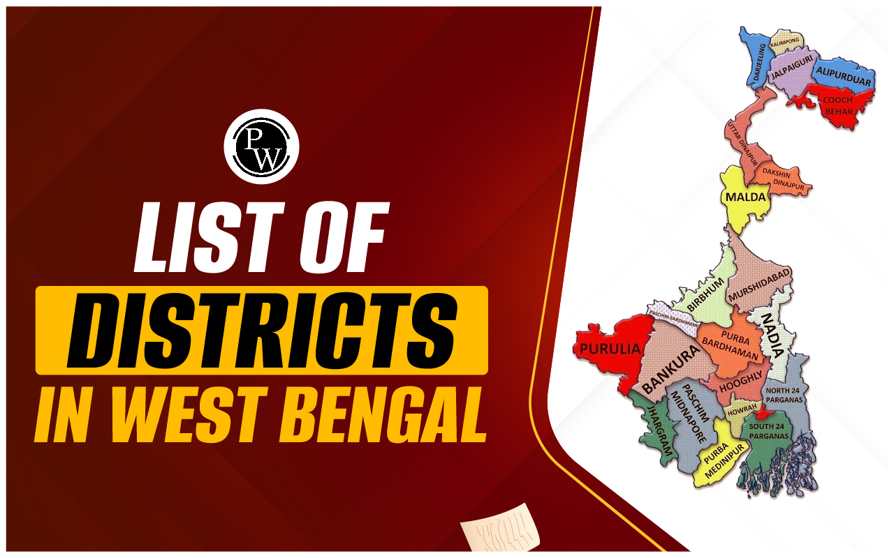
As of 2024, West Bengal is divided into 23 districts. These districts are categorized into several administrative divisions that facilitate better governance and administration. The districts vary significantly in terms of area, population, and development, reflecting the diverse landscape and demographics of the state.
Districts of West Bengal - Administrative Divisions
West Bengal is administratively divided into several districts, which are further grouped into divisions to streamline governance and administration. These administrative divisions facilitate efficient management of resources, implementation of policies, and coordination among various government departments. Each division comprises multiple districts, each with its own distinct characteristics and administrative significance.
| Districts of West Bengal - Administrative Divisions | |||||
|
Presidency Division |
Burdwan Division |
Medinipur Division |
Malda Division |
Jalpaiguri Division |
|
|
List of Districts |
Kolkata |
Paschim Bardhaman |
Purba Medinipur |
Malda |
Jalpaiguri |
|
Howrah |
Purba Bardhaman |
Paschim Medinipur |
Murshidabad |
Alipurduar |
|
|
North 24 Parganas |
Hoogly |
Bankura |
Uttar Dinajpur |
Cooch Behar |
|
|
South 24 Parganas |
Birbhum |
Purulia |
Dakshin Dinajpur |
Kalimpong |
|
|
Nadia |
Jhargram |
Darjeeling |
|||
West Bengal District’s Headquarters
The district headquarters in West Bengal serve as the administrative nerve centers, housing key government offices, district-level institutions, and administrative infrastructure. These headquarters play pivotal roles in governance, public service delivery, and coordination of developmental activities within their respective districts.
| West Bengal District’s Headquarters and Establishment Date | |||
|
Sl. No |
Name of District |
Name of Headquarter |
Date of Establishment |
| 1 |
Alipurduar |
Alipurduar |
2014 |
| 2 |
Bankura |
Bankura |
1947 |
| 3 |
Birbhum |
Suri |
1947 |
| 4 |
Cooch Behar |
Cooch Behar |
1950 |
| 5 |
Darjeeling |
Darjeeling |
1947 |
| 6 |
Dakshin Dinajpur |
Balurghat |
1992 |
| 7 |
Hoogly |
Chinsura |
1947 |
| 8 |
Howrah |
Howrah |
1947 |
| 9 |
Jalpaiguri |
Jalpaiguri |
1947 |
| 10 |
Jhargram |
Jhargram |
2017 |
| 11 |
Kalimpong |
Kalimpong |
2017 |
| 12 |
Kolkata |
Kolkata |
1947 |
| 13 |
Malda |
English Bazar |
1947 |
| 14 |
Murshidabad |
Baharampur |
1947 |
| 15 |
Nadia |
Krishnanagar |
1947 |
| 16 |
North 24 Parganas |
Barasat |
1986 |
| 17 |
Paschim Bardhaman |
Asansol |
2017 |
| 18 |
Paschim Medinipur |
Medinipur |
2002 |
| 19 |
Purba Bardhaman |
Bardhaman |
2017 |
| 20 |
Purba Medinipur |
Tamluk |
2002 |
| 21 |
Purulia |
Purulia |
1956 |
| 22 |
South 24 Parganas |
Alipore |
1986 |
| 23 |
Uttar Dinajpur |
Raiganj |
1992 |
List of Districts in West Bengal By Their Size and Population
West Bengal's districts exhibit considerable diversity in both their geographical size and population density. This variation influences local governance, resource allocation, and developmental priorities. Understanding the distribution of districts by their size and population provides insights into the demographic and spatial dynamics of the state.
West Bengal's districts vary significantly in terms of area and population. Here is a categorized list based on size and population:| List of Districts in West Bengal By Their Size and Population | |||
|
Sl. No |
Name of District |
Approx. Area |
Approx. Population |
| 1 |
Alipurduar |
3,383 km 2 |
1,491,250 |
| 2 |
Bankura |
6,882 km 2 |
3,596,674 |
| 3 |
Birbhum |
4,545 km 2 |
3,502,404 |
| 4 |
Cooch Behar |
3,387 km 2 |
2,819,086 |
| 5 |
Darjeeling |
2,093 km 2 |
1,595,181 |
| 6 |
Dakshin Dinajpur |
2,219 km 2 |
1,676,276 |
| 7 |
Hoogly |
3,149 km 2 |
5,519,145 |
| 8 |
Howrah |
1,467 km 2 |
4,850,029 |
| 9 |
Jalpaiguri |
2,844 km 2 |
2,381,596 |
| 10 |
Jhargram |
3,038 km 2 |
1,136,548 |
| 11 |
Kalimpong |
1,044 km 2 |
251,642 |
| 12 |
Kolkata |
185 km 2 |
4,496,694 |
| 13 |
Malda |
3,733 km 2 |
3,988,845 |
| 14 |
Murshidabad |
5,324 km 2 |
7,103,807 |
| 15 |
Nadia |
3,927 km 2 |
5,167,601 |
| 16 |
North 24 Parganas |
4,094 km 2 |
11,060,148 |
| 17 |
Paschim Bardhaman |
1,604 km 2 |
2,882,031 |
| 18 |
Paschim Medinipur |
6,308 km 2 |
4,776,909 |
| 19 |
Purba Bardhaman |
5,432 km 2 |
4,835,532 |
| 20 |
Purba Medinipur |
4,736 km 2 |
5,095,875 |
| 21 |
Purulia |
6,259 km 2 |
2,930,115 |
| 22 |
South 24 Parganas |
9,960 km 2 |
8,161,961 |
| 23 |
Uttar Dinajpur |
3,140 km 2 |
3,007,134 |
Largest District of West Bengal
The largest district in terms of area is South 24 Parganas, covering an expansive region that includes parts of the Sundarbans mangrove forest, a UNESCO World Heritage Site. This district is crucial for its biodiversity and ecological significance.
Smallest District in West Bengal
Kolkata, the capital city of West Bengal, is the smallest district by area. Despite its small size, it is the most densely populated and serves as the cultural, commercial, and educational hub of the state.
Districts in West Bengal By Population
- Most Populous: North 24 Parganas
- Least Populous: Kalimpong
New Districts in West Bengal
On August 1, 2022, the West Bengal Cabinet granted approval for the establishment of seven additional districts in West Bengal, expanding the total count from 23 to 30. The new districts and their respective areas are as follows:- Ichhamati District and Basirhat District will be formed by dividing the existing North 24 Parganas District.
- A new Sundarban District will emerge from portions of the South 24 Parganas District.
- Bishnupur District will be carved out from the existing Bankura district.
- Jangipur District and Berhampore District will be created by partitioning the Murshidabad District.
- A new Ranaghat District will be established from segments of the Nadia District.
List of Districts in West Bengal and Their Importance
West Bengal, a state steeped in history, culture, and diversity, is home to a mosaic of districts, each with its own unique significance. From bustling urban centers to serene rural landscapes, these districts contribute to the state's socio-economic fabric and cultural heritage. Understanding the importance of each district sheds light on their roles in governance, economy, and societal development.
| List of Districts in West Bengal and Their Importance | ||
|
Sl. No |
Name of District |
Economic Significance |
| 1 |
Alipurduar |
|
| 2 |
Bankura |
|
| 3 |
Birbhum |
|
| 4 |
Cooch Behar |
|
| 5 |
Darjeeling |
|
| 6 |
Dakshin Dinajpur |
|
| 7 |
Hoogly |
|
| 8 |
Howrah |
|
| 9 |
Jalpaiguri |
|
| 10 |
Jhargram |
|
| 11 |
Kalimpong |
|
| 12 |
Kolkata |
|
| 13 |
Malda |
|
| 14 |
Murshidabad |
|
| 15 |
Nadia |
|
| 16 |
North 24 Parganas |
|
| 17 |
Paschim Bardhaman |
|
| 18 |
Paschim Medinipur |
|
| 19 |
Purba Bardhaman |
|
| 20 |
Purba Medinipur |
|
| 21 |
Purulia |
|
| 22 |
South 24 Parganas |
|
| 23 |
Uttar Dinajpur |
|
Recent Developments in Districts of West Bengal
West Bengal, a state known for its dynamic culture and rich heritage, has been witnessing significant developmental strides across its diverse districts. From infrastructure upgrades to social welfare initiatives, recent developments reflect the state government's commitment to fostering inclusive growth and enhancing the quality of life for its citizens.
Some of the recent initiatives undertaken by the Central and State Governments in West Bengal are:
- Tajpur port in Purba Medinipur
- 100 Km cover of the Kolkata Metro.
- Bengal Silicon Valley project in the New Town of Kolkata.
- World Trade Center, Kolkata.
- Khadya Sathi (Food Security) and Swasthya Sathi Scheme of West Bengal Govt.
- Widening and Strengthening of NH 116 B by Union Road and Transport Ministry that connects Purba Medinipur district of West Bengal to Balasore district of Odisha.
- The second campus of the Chittaranjan National Cancer Institute (CNCI) is in Kolkata.
- Durgapur-Haldia pipeline project by GAIL.
Geographical, Economic, and Cultural Importance of the Districts in West Bengal
West Bengal, a state nestled in the eastern part of India, is renowned for its rich tapestry of geographical landscapes, vibrant economic activities, and diverse cultural heritage. The districts of West Bengal play a pivotal role in shaping the state's identity, contributing to its socio-economic development and cultural vibrancy. Each district boasts unique geographical features, economic strengths, and cultural treasures, making them integral components of the state's multifaceted identity.
| Geographical, Economic, and Cultural Importance of the Districts in West Bengal | |||
| District | Geographical Importance | Economic Importance | Cultural Importance |
|---|---|---|---|
| Alipurduar | Located in the foothills of the Eastern Himalayas, rich in biodiversity. | Tea cultivation and timber industry contribute to the economy. | Home to indigenous tribes with unique cultural traditions. |
| Bankura | Varied terrain including hills, forests, and plains. | Agriculture, particularly rice and oilseed cultivation, is significant. | Known for traditional art and crafts like Terracotta pottery and Dokra metal craft. |
| Birbhum | Red laterite soil supports agriculture, including the cultivation of pulses and oilseeds. | Famous for its Shantiniketan, a center of education and culture. | Renowned for Baul music and vibrant folk culture. |
| Cooch Behar | Bordering Assam and Bhutan, known for its lush greenery and tea gardens. | Tea and tourism are major contributors to the economy. | Rich in royal heritage and architectural landmarks like the Cooch Behar Palace. |
| Dakshin Dinajpur | Shares borders with Bangladesh, characterized by fertile plains. | Agriculture, particularly rice and jute cultivation, is predominant. | Influenced by the traditions of the Rajbanshi community and local folk art forms. |
| Darjeeling | Stunning landscape with the Himalayan mountain range and lush tea estates. | Tea industry and tourism are vital for the economy. | Famous for Darjeeling Himalayan Railway (Toy Train) and Tibetan Buddhist monasteries. |
| Hooghly | Situated along the banks of the Hooghly River, historically significant. | Industrial belt with manufacturing units and jute mills. | Home to historical landmarks like the Hooghly Imambara and Tarakeswar Temple. |
| Howrah | Located on the western bank of the Hooghly River, part of the Kolkata metropolitan area. | Industrial hub with steel, engineering, and manufacturing industries. | Notable for the iconic Howrah Bridge and religious festivals like the Rath Yatra. |
| Jalpaiguri | Borders Bhutan and Bangladesh, characterized by forests and tea gardens. | Tea cultivation, timber industry, and tourism are significant. | Diverse ethnic communities with unique cultural practices. |
| Jhargram | Hilly terrain with forests and tribal villages. | Agriculture and tourism, known for eco-tourism destinations. | Rich tribal heritage with traditional dances, music, and handicrafts. |
Districts in West Bengal FAQs
Q.1 What are the 23 districts in West Bengal?
Q.2 How many districts are in West Bengal in 2024?
Q.3 Is there 30 districts in West Bengal?
Q.4 Which is the richest district in West Bengal?
Q.5 Which is the biggest district in West Bengal?