

Latitudes and Longitudes of Earth, Complete Geography Notes
Latitudes and Longitudes: Latitude and longitude are part of a system of coordinates that are used to determine the location of any place on the Earth’s surface. Check complete notes on Latitudes and Longitudes here.
Latitudes and Longitudes: Latitudes and longitudes serve as imaginary lines on Earth's surface, aiding in locating specific places. These lines form a grid system known as the network of Meridians and Parallels. Often referred to as squares on maps, this grid helps in pinpointing locations by intersecting longitudes and latitudes. Longitudes are particularly significant for determining the local time of a place.
Latitudes and Longitudes
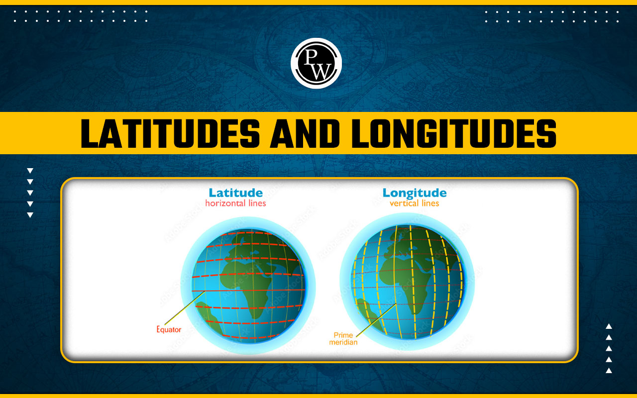
Latitude and longitude are geographical coordinates used to precisely locate points on the Earth's surface. Latitude measures the angular distance north or south of the equator, with the equator serving as the reference point at 0 degrees latitude. Longitude measures the angular distance east or west of the prime meridian, which passes through Greenwich, England. Together, latitude and longitude form a grid system, allowing for accurate navigation and mapping. They provide a universal method for specifying locations, enabling global communication, transportation, and scientific research. These coordinates play a crucial role in activities ranging from navigation and surveying to weather forecasting and satellite imagery.What is Latitude?
Latitude is like an imaginary set of lines that run horizontally around the Earth, starting from the middle called the Equator and reaching up to the top called the North Pole and down to the bottom called the South Pole. These lines help us locate places north or south of the Equator. They're called "parallels" because they run parallel to each other. Each latitude line is labeled with either N for north or S for south, depending on which side of the Equator it's on. For example, the latitude of Chennai is marked as 13°N. The Equator is the starting point, marked as 0 degrees, while the North Pole is at 90 degrees north, and the South Pole is at 90 degrees south. These lines are drawn one degree apart from each other. There are 179 latitude lines in total: 89 in the Northern Hemisphere, 89 in the Southern Hemisphere, and one at the Equator. Important lines include the Equator itself, the Tropic of Cancer, the Tropic of Capricorn, the Antarctic Circle, and the Arctic Circle. The distance between each degree of latitude is about 69 miles or 111 kilometers on average, but it's a bit longer at the poles than at the Equator. You can even figure out a place's latitude by looking at the position of the Pole Star in the sky.What is Longitude?
Longitude is like another set of imaginary lines on Earth, but this time they run vertically from top to bottom, starting at the Prime Meridian. The Prime Meridian is like the center line, and longitudes are measured in degrees east or west from there. Unlike latitudes, which are parallel, longitudes are not parallel. Instead, they converge at the North and South Poles. The Prime Meridian is marked as 0 degrees, and longitudes are numbered from 0 to 180 degrees east or west. The part of Earth to the east of the Prime Meridian is called the Eastern Hemisphere, while the part to the west is called the Western Hemisphere. Lines of longitude, also called meridians, intersect with the Equator at right angles. Places on the same longitude experience noon at the same time. Longitudes split the Earth into two halves: the Eastern Hemisphere and the Western Hemisphere. The distance between each degree of longitude varies. It's maximum at the Equator, about 69.172 miles, because the difference between two longitudes is greatest there. It's minimal at the Poles because the longitudes come together at the poles.Difference Between Latitudes and Longitudes
Difference Between Latitudes and Longitudes is as follows:| Difference Between Latitudes and Longitudes | |
|---|---|
| Longitude | Latitude |
| These lines are called meridians. | These lines are called parallels. |
| They contain 360 longitudinal lines on the Prime Meridian, measuring east-to-west distance. | They contain 180 latitudinal lines on the Prime Equator. |
| They are imaginary lines that run vertically on the Earth's surface. | Latitudes are imaginary lines that run horizontally across the Earth's surface. |
| They classify time zones. | Latitudes classify heat zones. |
| Longitudes are used to determine time zones across the Earth. | Latitude designates heat fields in different parts of the Earth. |
| Longitude measures the distance east or west of the Prime Meridian. | Latitude measures the distance north or south of the equator. |
Latitudes and Longitudes Reading
Latitudes and longitudes are geographical coordinates used to pinpoint precise locations on the Earth's surface. Latitudes are horizontal lines running parallel to the equator, indicating positions north or south of it. Longitudes are vertical lines running from the North Pole to the South Pole, showing positions east or west of the prime meridian. Together, they form a global grid system, enabling accurate navigation, mapping, and communication. Latitudes and longitudes are fundamental for various applications, including GPS navigation, weather forecasting, and geographic information systems (GIS). Understanding these coordinates is essential for interpreting and communicating location-based information effectively. To succeed in upcoming exams, candidates should consider exploring PW SSC Books We provide high-quality content at an affordable price, including sample papers, mock tests, guidance sessions, and more to ensure aspirants secure their selection. Also, enroll today on SSC Online Coaching to turn your dreams into reality.| Other Related Links | |
| Tiger Reserves in India | National Parks in India |
| Biosphere Reserves in India | Elephant Reserves in India |
Latitudes and Longitudes FAQs
Is latitude north or south?
Latitudes are horizontal lines running on the surface of the earth.
Which Indian place is closest to the Equator?
Indira Point is closest to the equator.
What is difference between longitude and latitude?
The difference between Latitude and Longitude is that Latitude measures the distance from the equator; while Longitude measures the distance from the Prime Meridian.


🔥 Trending Blogs
Talk to a counsellorHave doubts? Our support team will be happy to assist you!


Check out these Related Articles


Join 15 Million students on the app today!

Free Learning Resources
PW Books
Notes (Class 10-12)
PW Study Materials
Notes (Class 6-9)
Ncert Solutions
Govt Exams
Our Other Websites
Class 6th to 12th Online Courses
Govt Job Exams Courses
UPSC Coaching
Defence Exam Coaching
Gate Exam Coaching
Other Exams
Know about Physics Wallah
Physics Wallah is an Indian edtech platform that provides accessible & comprehensive learning experiences to students from Class 6th to postgraduate level. We also provide extensive NCERT solutions, sample paper, NEET, JEE Mains, BITSAT previous year papers & more such resources to students. Physics Wallah also caters to over 3.5 million registered students and over 78 lakh+ Youtube subscribers with 4.8 rating on its app.
We Stand Out because
We provide students with intensive courses with India’s qualified & experienced faculties & mentors. PW strives to make the learning experience comprehensive and accessible for students of all sections of society. We believe in empowering every single student who couldn't dream of a good career in engineering and medical field earlier.
Our Key Focus Areas
Physics Wallah's main focus is to make the learning experience as economical as possible for all students. With our affordable courses like Lakshya, Udaan and Arjuna and many others, we have been able to provide a platform for lakhs of aspirants. From providing Chemistry, Maths, Physics formula to giving e-books of eminent authors like RD Sharma, RS Aggarwal and Lakhmir Singh, PW focuses on every single student's need for preparation.
What Makes Us Different
Physics Wallah strives to develop a comprehensive pedagogical structure for students, where they get a state-of-the-art learning experience with study material and resources. Apart from catering students preparing for JEE Mains and NEET, PW also provides study material for each state board like Uttar Pradesh, Bihar, and others
Copyright © 2026 Physicswallah Limited All rights reserved.