Full Form of RL in Civil Engineering
RL full form in Civil Engineering is “Reduced Levels”. How to Calculate the RL and Rise and Fall Method. Check the complete information on RL in Civil Engineering here.
What is a Reduced Level in Civil Engineering?
Reduced level in civil engineering is a term that refers to equating the elevation of survey points. These survey points are equated with the help of an assumed datum.
This is a vertical distance that is above or below the datum plane, and the most common datum is mean sea level.
In simpler terms, "reduced level" is a term to describe a comparison in height. In technical terms, it is the height between the point of interest and the adopted level datum.
How to Calculate the Reduced Level (RL)?
The reduced level (RL) can be measured using two methods:
- The rise and fall method
- The height of the instrument method
The Rise and Fall Method
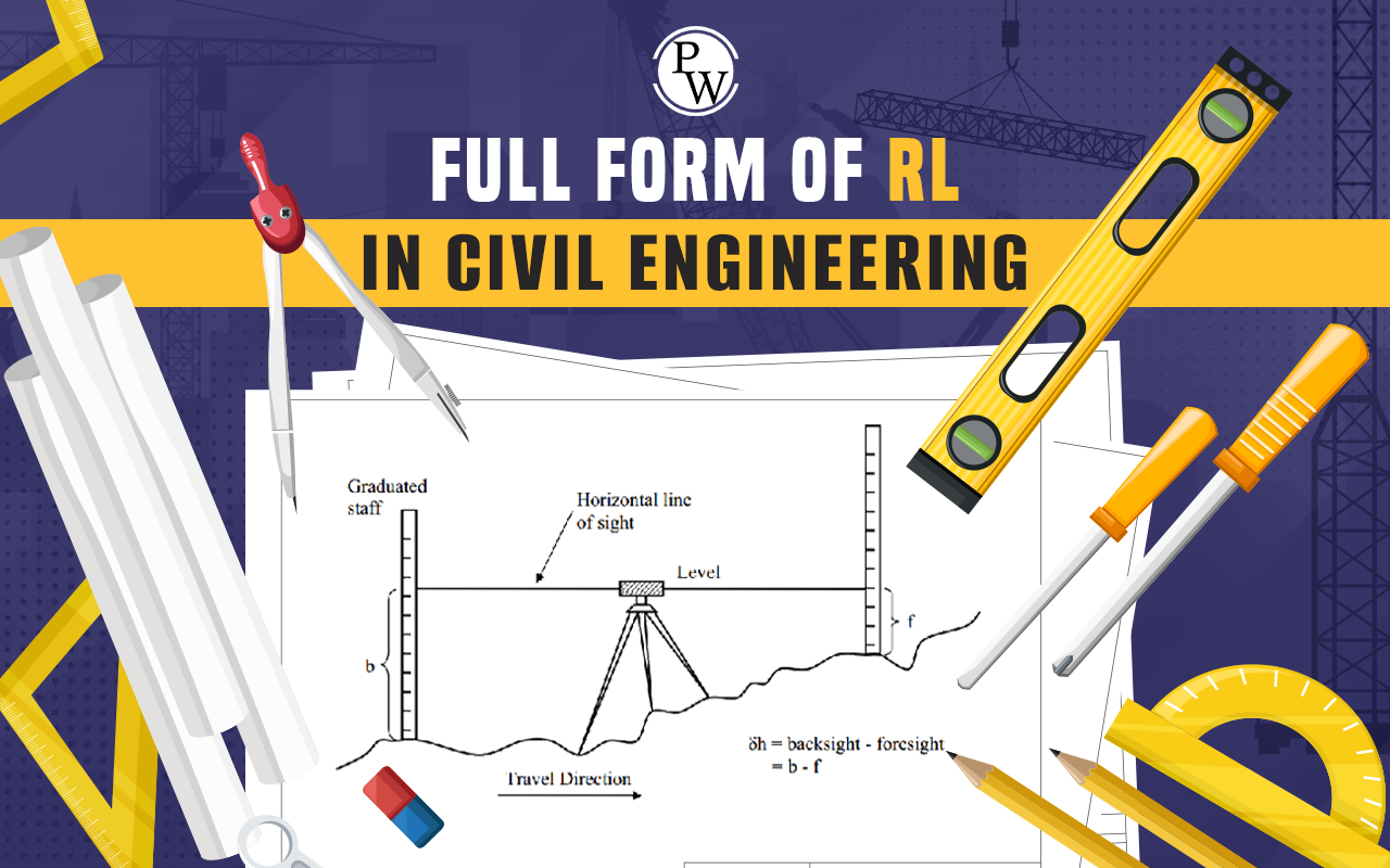
- The rise and fall method is one wherein the difference between consecutive points is calculated by comparing each point after the first with the points preceding it.
- Basically, the difference in the reading indicates the rise or fall of any reading that is smaller or greater than the preceding point.
How to Calculate the RL of Each Point
- The reduced level of each point is calculated by adding or subtracting the rise to or from the previous point's reduced level.
- For instance, if B.S. (backsight) - F.S. (foresight) is positive, then there is a rise.
- If, however, the B.S.-F.S. is negative, then there is a fall.
- Therefore, the R.L. is equal to the R.L. of the previous point plus the rise or fall.
- To check Σ B S. – Σ F.S. = Σ Rise – Σ fall = (First R.L.) – (Last R.L.)
What are the Specifications of this Method?
The specifications of this method are as follows:
- Firstly, it is both slow and simple.
- Secondly, it is precise as it considers the immediate sight.
- It is a laborious method.
- A thorough examination of the reduction of the reduced levels of the immediate station is carried out.
- For arithmetic accuracy, three checks are conducted, and the difference between the sum of the backsight and the foresight should be equal to the sum of the rise and fall between the first and last R.L.
- It is used primarily for calculating earthwork and other levelling operations that need precision.
Height of Instrument Method
- The height of the instrument method includes finding the elevation of the plane of collimation which is also called H.I.
- This is done for every setting of the instrument, and obtaining the reduced levels of the points using references according to the respective plan of the collimation.
- Firstly, the H.I. is calculated by adding the reduced level (of the starting point) to the backsight. I.e. H.I. = R.L. + B.S.
- Secondly, the reduced level (R.L.) of the immediate point and the first change point are obtained by subtracting the readings from the H.I.
- Additionally, when the instrument is shifted, a new plane of collimation is set up. Here, the height is calculated by adding the backsight reading to the reduced level of the first change point.
- The reduced level (R.L.) of the successive points as well as the second change point are determined by subtracting the staff reading from the new H.I.
- Most importantly, this process is repeated until every reduced level is worked out. After that, the arithmetic check takes place which is Σ B.S. – Σ F.S. = Last R.L. - First R.L.
What are the Specifications of this Method?
- The height of the instrument method only involves a few calculations. Therefore, it is less time-consuming, less labor-intensive, and saves time when it comes to immediate reading.
- There is no check on the reduced levels of intermediate stations.
- Additionally, there are two checks done for arithmetic accuracy. In other words, the difference between the sum of the backsight and that of the foresight should be equal to the difference between the first R.L. and the last R.L.
- Lastly, it is widely used for longitudinal operations as well as cross-leveling operations.
[wp-faq-schema title=" Full Form of RL FAQs" accordion=1]
What does RL level stand for?
In simple terms, RL stands for "reduced levels," which represents a height that is either above or below a nominated datum.
What is the rise and fall method of leveling?
In simple words, the rise and fall method is the following:
It consists of finding or establishing the difference in elevation between consecutive points. This is done by comparing each point after the first one preceding it.
What do you mean by positive RL and negative RL?
A reduced level can either be a positive RL or negative RL depending on the point that is above or below the datum. For instance, if B.S. (backsight) - F.S. (foresight) is positive, then there is a rise. If, however, the B.S.-F.S. is negative, then there is a fall.
Talk to a counsellorHave doubts? Our support team will be happy to assist you!

Join 15 Million students on the app today!

Free Learning Resources
PW Books
Notes (Class 10-12)
PW Study Materials
Notes (Class 6-9)
Ncert Solutions
Govt Exams
Our Other Websites
Class 6th to 12th Online Courses
Govt Job Exams Courses
UPSC Coaching
Defence Exam Coaching
Gate Exam Coaching
Other Exams
Know about Physics Wallah
Physics Wallah is an Indian edtech platform that provides accessible & comprehensive learning experiences to students from Class 6th to postgraduate level. We also provide extensive NCERT solutions, sample paper, NEET, JEE Mains, BITSAT previous year papers & more such resources to students. Physics Wallah also caters to over 3.5 million registered students and over 78 lakh+ Youtube subscribers with 4.8 rating on its app.
We Stand Out because
We provide students with intensive courses with India’s qualified & experienced faculties & mentors. PW strives to make the learning experience comprehensive and accessible for students of all sections of society. We believe in empowering every single student who couldn't dream of a good career in engineering and medical field earlier.
Our Key Focus Areas
Physics Wallah's main focus is to make the learning experience as economical as possible for all students. With our affordable courses like Lakshya, Udaan and Arjuna and many others, we have been able to provide a platform for lakhs of aspirants. From providing Chemistry, Maths, Physics formula to giving e-books of eminent authors like RD Sharma, RS Aggarwal and Lakhmir Singh, PW focuses on every single student's need for preparation.
What Makes Us Different
Physics Wallah strives to develop a comprehensive pedagogical structure for students, where they get a state-of-the-art learning experience with study material and resources. Apart from catering students preparing for JEE Mains and NEET, PW also provides study material for each state board like Uttar Pradesh, Bihar, and others
Copyright © 2026 Physicswallah Limited All rights reserved.