-
Aligned with the latest CBSE syllabus and exam pattern for 2025-26.
-
Provides complete and accurate answers to all textbook questions and activities.
-
Helps in understanding important concepts like latitudes, longitudes, and time zones clearly.
-
Enhances map reading and interpretation skills through practical exercises.
-
Useful for quick revision and self-study before exams.
-
Boosts confidence by improving accuracy and conceptual clarity


NCERT Solutions for Class 6 Social Science Chapter 1 Question Answer PDF
Find easy and complete NCERT Solutions for Class 6 Social Science Chapter 1 – Locating Places on the Earth. These answers follow the latest 2025-26 CBSE syllabus and help students understand maps, directions, latitudes, and longitudes.

NCERT Solutions for Class 6 Social Science Chapter 1: This chapter introduces students to key geographical concepts like latitudes, longitudes, and the globe.
It helps build a strong foundation for map-reading and understanding the Earth's coordinates. The CBSE Class 6 Social Science syllabus simplify complex ideas and are aligned with the latest exam pattern and syllabus.
These solutions are useful for quick revision and conceptual clarity. Practicing questions from this chapter, along with previous year papers, helps students perform better in exams and builds confidence. Ideal for CBSE Class 6 Social Science preparation, these solutions ensure students grasp basic geography effectively.
NCERT Solutions for Class 6 Social Science Chapter 1 Introduction
Chapter 1 of Class 6 Social Science focuses on how we locate places on Earth using imaginary lines like latitudes and longitudes. It introduces the concept of the globe, equator, prime meridian, and time zones, helping students understand how different parts of the world are positioned. These concepts are essential for understanding maps and global navigation.
The chapter builds a strong foundation in geography, aligning with the latest CBSE syllabus. The NCERT solutions make these topics easier to grasp and prepare students well for exams through structured questions and clear explanations.
NCERT Solutions for Class 6 Social Science Chapter 1 Locating Places on the Earth
Below are the complete solutions to all questions and activities from this chapter. These answers are designed to help students understand key concepts such as maps, latitudes, longitudes, and time zones, while aligning with the latest syllabus and exam pattern. Use them for effective revision and better exam preparation.
LET’S EXPLORE (Page 9)
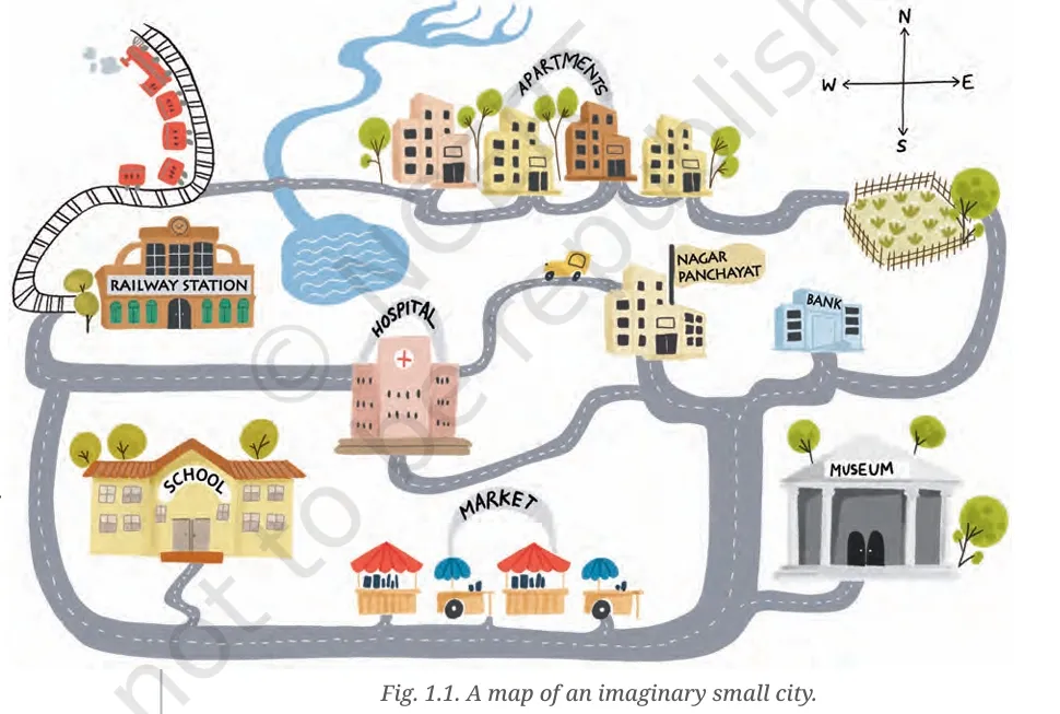
1. Mark the hospital.
Ans. Refer to the map in Fig. 1.1 (Page 8); the hospital is located on the northwestern side of the city.
2. What is the meaning of the blue-coloured areas?
Ans. The blue-coloured areas represent water bodies such as lakes and rivers.
3. Which is farther away from the railway station — the school, the Nagar Panchayat or the public garden?
Ans. The public garden is farthest from the railway station.
LET’S EXPLORE (Page 10)
1. Draw a simple map of a school’s playground. Let us assume it is a rectangle, 40 m in length and 30 m in width. Draw it precisely with your ruler on a scale of 1 cm = 10 m.
Ans. Draw a rectangle of 4 cm by 3 cm using a ruler, representing 40 m by 30 m.
2. Now measure the diagonal of the rectangle. How many centimetres do you get? Using the scale, calculate the real length of the playground’s diagonal, in metres.
Ans. Using the Pythagoras Theorem:
Diagonal = √(4² + 3²) = √(16 + 9) = √25 = 5 cm
Real diagonal = 5 cm × 10 m = 50 metres
LET’S EXPLORE (Page 11)
1. Consider the map of the small city again. Identify the correct and incorrect statements in the list below:
-
The market is north of the hospital. — Incorrect
-
The museum is southeast of the bank. — Correct
-
The railway station is northwest of the hospital. — Correct
-
The lake is northwest of the apartment blocks. — Incorrect
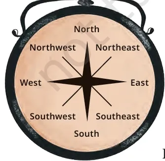
2. Taking your school as the starting point, do you know approximately in which cardinal direction your home is located?
Ans. Students should discuss this with the teacher. For example: "My home is in the northeast direction from the school."
LET’S EXPLORE (Page 11 – Symbol Activity)
Draw a rough map of your locality or your village, including your home, school and a few other important landmarks. Show the cardinal directions and use a few of the symbols shown in Fig. 1.2 to mark some important features.
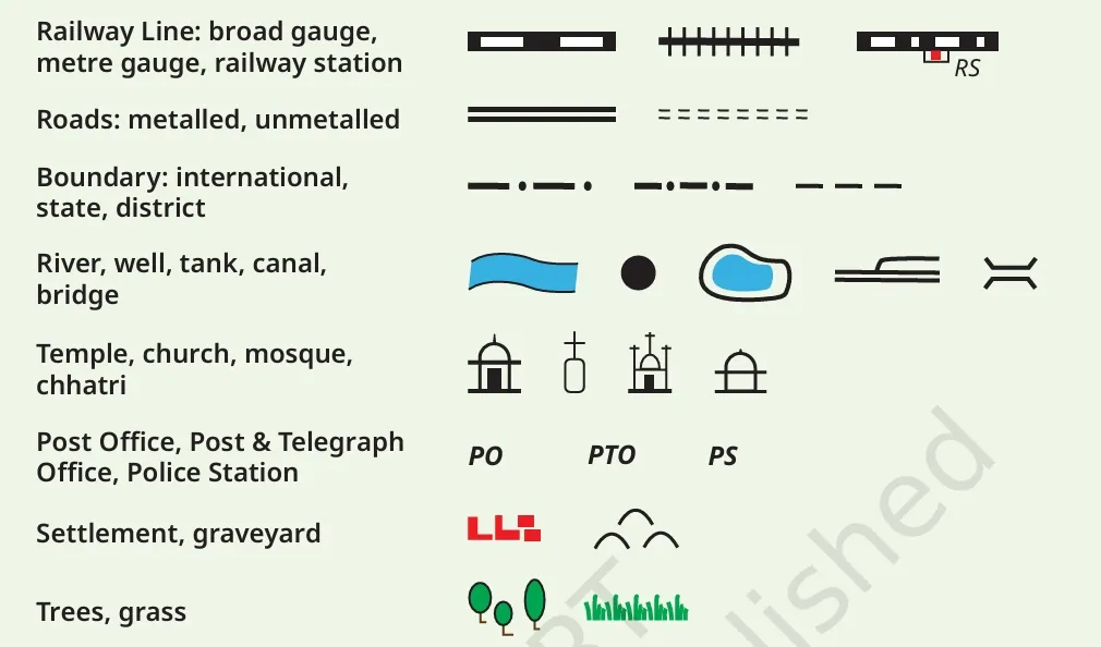
Ans. Students should draw a simple layout with symbols like ⛪ (temple), 📮 (post office), 🏫 (school), 🚓 (police station), 🌳 (trees), and roads/railways using conventional map symbols.
LET’S EXPLORE (Page 13)
Using the same terms, write down your move if you play black and respond with the same move.
Ans. White moved d2 to d4.
Black should move d7 to d5.
LET’S EXPLORE (Page 17)
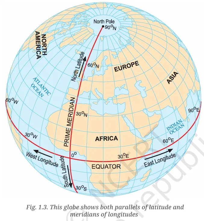
If the globe or atlas in your class has well-marked latitudes and longitudes, try to note down approximate values for the latitude and longitude of:
-
(1) Mumbai – 19°N, 72.8°E
-
(2) Kolkata – 22.6°N, 88.4°E
-
(3) Singapore – 1.3°N, 103.8°E
-
(4) Paris – 48.9°N, 2.3°E
LET’S EXPLORE (Page 21)
Two friends, one in Porbandar and one in Tinsukia, are speaking. The sun has set in Assam but not in Gujarat. Explain why.
Ans. India spans a wide longitudinal range. Tinsukia (Assam) lies to the east and experiences sunrise and sunset earlier than Porbandar (Gujarat). The Earth rotates from west to east, so eastern regions experience daylight before western ones.
Calculate the difference in local time.
Ans. If the longitudinal difference is 30°, the time difference is 30 ÷ 15 = 2 hours.
LET’S EXPLORE (Page 21)
Use the example to explain the difference between local time and standard time.
Ans. Local time is based on the actual position of the sun at a specific longitude. Standard time is the uniform time fixed for a country based on a selected meridian. Though Assam and Gujarat have different local times, both follow Indian Standard Time (IST), based on 82.5°E.
QUESTIONS, ACTIVITIES AND PROJECTS (Page 24–25)
1. Calculate the real distance from the estuary of the Narmada River to the estuary of the Ganga river.
Ans. Assuming a measurement of 5 cm on the map and scale of 2.5 cm = 500 km,
Real distance = 5 cm ÷ 2.5 cm × 500 km = 1000 km
2. Why is it 5:30 pm in India when it is 12 pm or noon in London?
Ans. India lies 82.5° east of Greenwich. Every 15° of longitude equals 1 hour of time difference.
82.5 ÷ 15 = 5.5 hours. So, IST is 5 hours 30 minutes ahead of GMT.
3. Why do we need symbols and colours in the map?
Ans. Symbols and colours help to represent features like roads, rivers, cities, and forests clearly and concisely, especially when space is limited.
4. Find out what you have in the eight directions from your home or school.
Ans. Students should survey and list:
-
North: Temple
-
South: Playground
-
East: Library
-
West: Market
-
NE: Hospital
-
SE: Bus stand
-
SW: Post office
-
NW: School building
5. What is the difference between local time and standard time?
Ans. Local time is based on the position of the sun at a specific place; it changes with longitude. Standard time is fixed across a country to avoid confusion.
For example, although sunrise in Assam is earlier than in Gujarat, both use IST (Indian Standard Time), which is 5 hours 30 minutes ahead of GMT. This simplifies scheduling and communication.
6. Delhi’s and Bengaluru’s latitudes are 29°N and 13°N; their longitudes are almost the same. How much will be the difference in local time between the two cities?
Ans. Since their longitudes are the same, there is no difference in local time between Delhi and Bengaluru.
7. Mark the following statements as true or false; explain your answers.
-
All parallels of latitude have the same length. — False
Only the Equator is the longest; others get shorter as we move toward the poles. -
The length of a meridian of longitude is half of that of the Equator. — True
Meridians are half-circles, whereas the Equator is a full circle. -
The South Pole has a latitude of 90°S. — True
-
In Assam, the local time and the IST are identical. — False
Assam is ahead in local time compared to IST. -
Lines separating the time zones are identical with meridians of longitude. — False
They are adjusted to match country borders. -
The Equator is also a parallel of latitude. — True
8. Solve the crossword
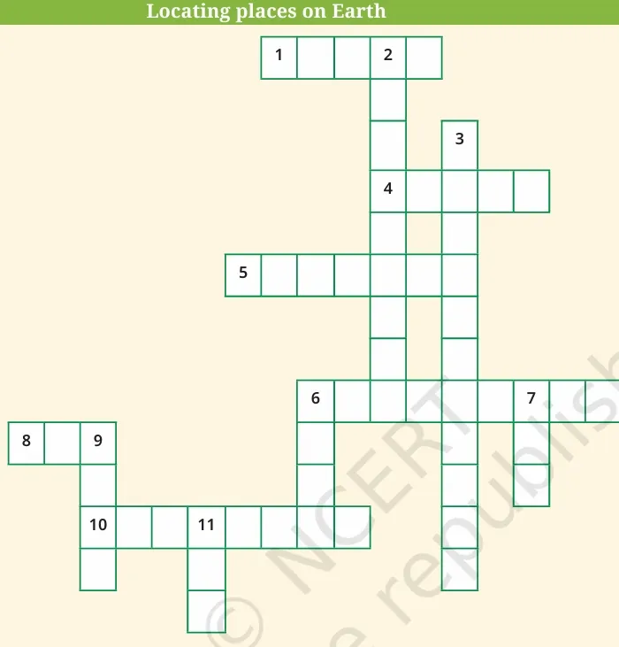
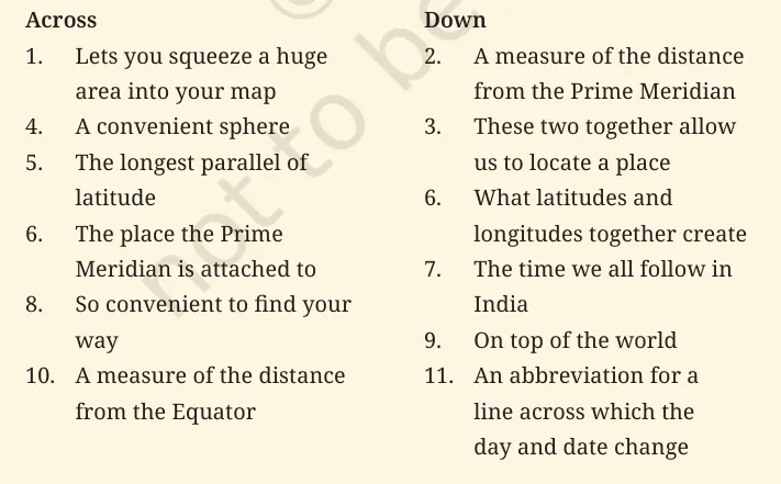
Across
-
Scale
-
Globe
-
Equator
-
Greenwich
-
Map
-
Latitude
Down
2. Longitude
3. Coordinates
6. Grid
7. IST
9. Pole
11. IDL
NCERT Solutions for Class 6 Social Science Chapter 1 PDF Download
To make learning easier and more accessible, we have provided the complete NCERT Solutions for Class 6 Social Science Chapter 1 – Locating Places on the Earth in a downloadable PDF format below.
This PDF includes answers to all textbook questions, activities, and exercises, based on the latest CBSE syllabus and exam pattern. Students can use this for quick reference, revision, and practice to strengthen their understanding of important geography concepts.
NCERT Solutions for Class 6 Social Science Chapter 1
Study without using the internet
Benefits of Using NCERT Solutions for Class 6 Social Science Chapter 1
Below we have provided the benefits of using NCERT solutions for class 6 social science chapter 1 -
NCERT Solutions for Class 6 Social Science Chapter 1 FAQs
Are these solutions based on the latest NCERT syllabus?
Yes, they follow the 2025-26 CBSE curriculum.
Why is there no year zero in the Gregorian calendar?
The Gregorian calendar moves directly from 1 BCE to 1 CE, with no year 0 in between.
Do the solutions cover all textbook questions?
Yes, all questions, activities, and exercises are fully answered.
Is this useful for map-based questions?
Yes, it includes guidance on interpreting and drawing maps.

🔥 Trending Blogs
Talk to a counsellorHave doubts? Our support team will be happy to assist you!

Check out these Related Articles


Join 15 Million students on the app today!

Free Learning Resources
PW Books
Notes (Class 10-12)
PW Study Materials
Notes (Class 6-9)
Ncert Solutions
Govt Exams
Our Other Websites
Class 6th to 12th Online Courses
Govt Job Exams Courses
UPSC Coaching
Defence Exam Coaching
Gate Exam Coaching
Other Exams
Know about Physics Wallah
Physics Wallah is an Indian edtech platform that provides accessible & comprehensive learning experiences to students from Class 6th to postgraduate level. We also provide extensive NCERT solutions, sample paper, NEET, JEE Mains, BITSAT previous year papers & more such resources to students. Physics Wallah also caters to over 3.5 million registered students and over 78 lakh+ Youtube subscribers with 4.8 rating on its app.
We Stand Out because
We provide students with intensive courses with India’s qualified & experienced faculties & mentors. PW strives to make the learning experience comprehensive and accessible for students of all sections of society. We believe in empowering every single student who couldn't dream of a good career in engineering and medical field earlier.
Our Key Focus Areas
Physics Wallah's main focus is to make the learning experience as economical as possible for all students. With our affordable courses like Lakshya, Udaan and Arjuna and many others, we have been able to provide a platform for lakhs of aspirants. From providing Chemistry, Maths, Physics formula to giving e-books of eminent authors like RD Sharma, RS Aggarwal and Lakhmir Singh, PW focuses on every single student's need for preparation.
What Makes Us Different
Physics Wallah strives to develop a comprehensive pedagogical structure for students, where they get a state-of-the-art learning experience with study material and resources. Apart from catering students preparing for JEE Mains and NEET, PW also provides study material for each state board like Uttar Pradesh, Bihar, and others
Copyright © 2026 Physicswallah Limited All rights reserved.