
NCERT Solutions for Class 6 Social Science Chapter 2 Question Answer PDF


The NCERT Solutions for Class 6 Social Science Chapter 2 Oceans and Continents help you learn about the world’s major oceans and continents in an easy way.
These solutions are based on the latest CBSE Class 6 Social Science syllabus and follow the class 6 exam, so they are useful for your tests. By practicing these answers along with previous year papers, you can get better at map questions and do well in your exams.
These solutions make it simple to understand the chapter and are great for revision. They will also help you feel more confident while preparing for your Social Science exam.
NCERT Solutions for Class 6 Social Science Chapter 2 Oceans and Continents
Chapter 2 Oceans and Continents helps us learn about the large land areas and water bodies that cover our Earth. It introduces the seven continents — like Asia, Africa, and Europe — and the five main oceans — such as the Pacific and Atlantic.
The chapter explains where these continents and oceans are located on a map and tells us some interesting facts about them.
This lesson helps students understand the basic structure of our planet and improves their map skills, which are useful for exams and activities in Social Science.
NCERT Solutions for Class 6 Social Science Chapter 2 Question Answers
Looking for NCERT Solutions for Class 6 Social Science Chapter 2 Oceans and Continents? These solutions cover all important questions, activities, and map work as per the latest syllabus and exam pattern.
Practicing these will help you prepare better for exams. Check the complete solutions below and strengthen your understanding of continents, oceans, and their importance.
1. What are oceans and continents? What are their names and their distribution?
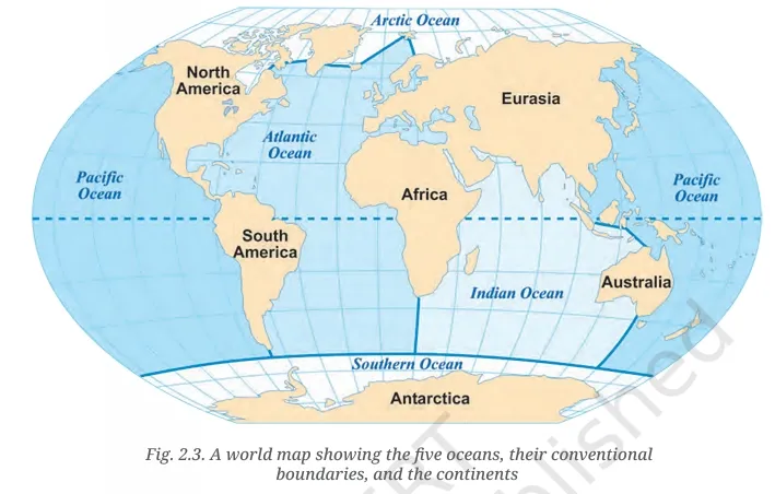
Oceans are the large water bodies covering nearly three-fourths of the Earth's surface. The five major oceans are the Pacific, Atlantic, Indian, Southern (or Antarctic), and Arctic Oceans.
Continents are large continuous masses of land covering a little over one-fourth of Earth. The seven continents are Asia, Africa, North America, South America, Antarctica, Europe, and Australia. Oceans and continents are not evenly spread across the Northern and Southern Hemispheres — the Northern Hemisphere has more land, while the Southern Hemisphere has more water.
2. In what ways do oceans and continents impact life on Earth, including human life?
Oceans and continents shape the Earth's climate, produce rainfall, and support plant and animal life. Oceans provide oxygen and regulate climate, acting as the planet’s lungs.
They support marine life and influence human activities like trade, fishing, and migration. Continents provide habitat and resources for humans, plants, and animals.
LET’S EXPLORE
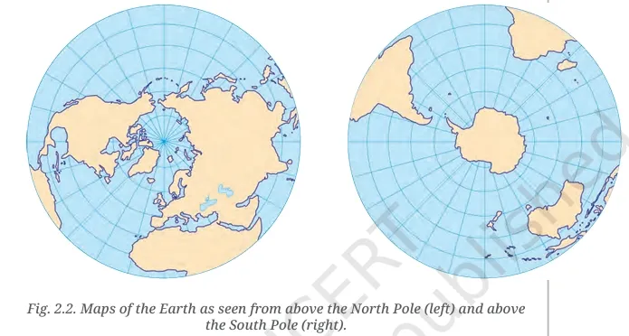
What are the circular lines in each map called? And do you know what the lines radiating out of the two poles are called?
The circular lines are lines of latitude (parallels). The lines radiating from the poles are lines of longitude (meridians).
Which hemisphere holds more water?
The Southern Hemisphere holds more water.
What do you think could be the approximate proportion of water to land in the Northern Hemisphere? And in the Southern Hemisphere?
In the Northern Hemisphere: about 60% water, 40% land.
In the Southern Hemisphere: about 80% water, 20% land.
Are all the oceans connected with one another, or are there separations between them?
Yes, all the oceans are connected, and seawater flows between them freely.
LET’S EXPLORE (p.32)
Locate the five oceans and, in the table below, mark the hemisphere or hemispheres they belong to.
| Ocean | Northern Hemisphere | Southern Hemisphere |
|---|---|---|
| Pacific Ocean | Yes | Yes |
| Atlantic Ocean | Yes | Yes |
| Indian Ocean | Yes | Yes |
| Southern Ocean | No | Yes |
| Arctic Ocean | Yes | No |
LET’S EXPLORE (p.36)
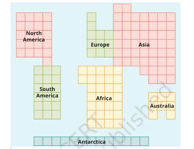
Counting the numbers of squares, name the largest continent and the smallest.
The largest continent is Asia. The smallest is Australia.
Which one is larger — North America or South America? Africa or North America? Antarctica or Australia?
North America is larger than South America.
Africa is larger than North America.
Antarctica is larger than Australia.
Re-colour the diagram by having a single colour for Europe and Asia and rename the result as ‘Eurasia’. Compare its size with South America’s.
Eurasia is much larger than South America.
Write down the list of continents from the smallest to the largest.
Australia, Europe, Antarctica, South America, North America, Africa, Asia.
THINK ABOUT IT
If there is such abundance of water on the planet, why is there so much talk of ‘water scarcity’ or a ‘water crisis’?
Most of the Earth’s water is salty and not fit for drinking or farming. Freshwater is very limited and unevenly distributed, leading to water scarcity in many areas.
What ways of saving water are you aware of? Which ones have you seen practised at home, at your school, and in your village, town or city?
Ways to save water: fixing leaks, using buckets instead of showers, rainwater harvesting, reusing water for gardening, turning off taps when not needed. At home and school, I have seen people use water carefully and install rainwater harvesting systems.
1. Explain the following terms:
(a) Continent
A large continuous landmass on Earth.
(b) Ocean
A large body of saltwater that covers much of Earth’s surface.
(c) Island
A piece of land surrounded by water on all sides.
2. Let us draw
(Students should try drawing the continents freehand and colour them. Then compare with the map in the chapter.)
3. Let us do
(Students should label the continents and oceans on the provided outline map.)
4. Solve this crossword
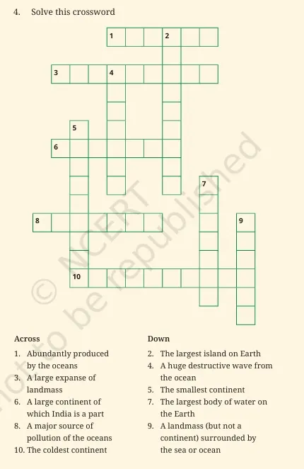
Across
-
Oxygen
-
Continent
-
Asia
-
Plastic
-
Antarctica
Down
2. Greenland
4. Tsunami
5. Australia
7. Pacific
9. Island
NCERT Solutions for Class 6 Social Science Chapter 2 PDF Download
If you are searching for NCERT Solutions for Class 6 Social Science Chapter 2 question answers PDF download, you are in the right place.
These solutions are prepared according to the latest Class 6 syllabus and exam pattern to help you with your studies and revision. Practicing these solutions will also help you in solving map-based and previous year questions confidently.
Below, we have provided the PDF for easy download so you can access it anytime and study at your convenience.
NCERT Solutions for Class 6 Social Science Chapter 2
Study without using the internet
Preparation Tips for Class 6 Social Science Chapter 2 Oceans and Continents
Below we have provided Preparation Tips for Class 6 Social Science Chapter 2 Oceans and Continents -
1. Focus on maps
Practice locating all continents and oceans on blank world maps. This will help you in answering map-based questions easily in exams.
2. Understand key terms
Learn and remember important terms like continent, ocean, island, latitude, longitude, tsunami, and cyclone. Write them down with simple meanings.
3. Make charts and tables
Create simple tables showing the size order of continents and oceans, and the proportion of land and water in each hemisphere.
4. Revise regularly
Go through your NCERT solutions and class notes multiple times. Regular revision will help you remember facts for the exam.
5. Solve previous year papers
Try previous year question papers and sample papers to understand the exam pattern and the types of questions asked.
6. Discuss activities and questions
Talk about the Let’s Explore and Think About It activities with classmates or at home to strengthen your understanding.
7. Use flashcards
Prepare flashcards for facts like largest ocean, smallest continent, largest island, etc. for quick and easy revision.
NCERT Solutions for Class 6 Social Science Chapter 2 FAQs
What is Chapter 2 Oceans and Continents about?
How can NCERT Solutions help in understanding this chapter?
How many oceans are on Earth?
Can I find solved questions and activities in these NCERT Solutions?