UPSC Notes: McMahon Line, History, Map, Length, LAC
McMahon Line: The McMahon Line carries significant geopolitical significance while shaping the boundaries between India and Tibet. This boundary ranges from 890 Kilometers, this boundary acts as a division between the northeastern region of India and Tibet.
Despite its importance, the legal status of the McMahon Line remains disputed, particularly by China, which makes it the focal point of tension in the India-China border dispute. In this informative guide, we will provide an overview of the history of the McMahon Line, its significance along the India-Tibet border, and its relation to the Line of Actual Control (LAC).
What is the McMahon Line?
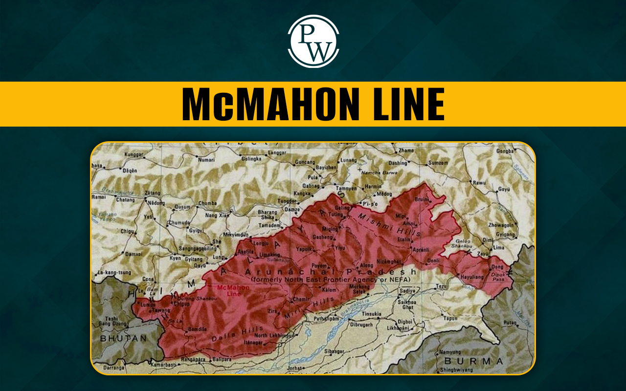
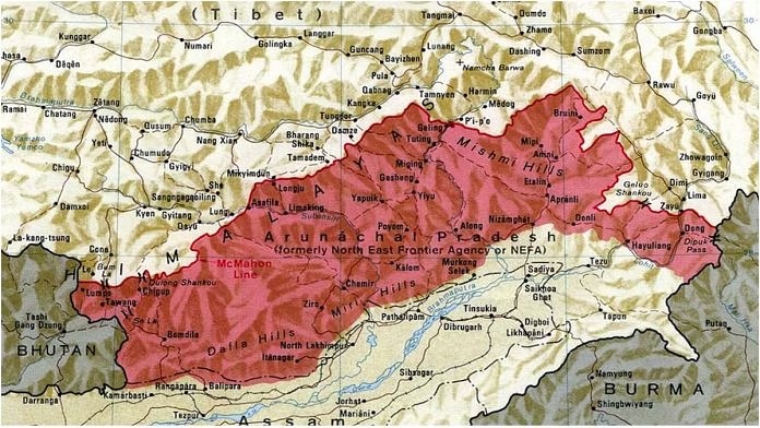
The McMahon Line is a geographically important boundary line that ranges from the eastern border of Bhutan along the range of the Himalayas , stretching to the great bend of the Brahmaputra River , where the river enters the Assam Valley from Tibet. The total length of the McMahon Line is 890 kilometres . This line separates the northeastern part of India, specifically Arunachal Pradesh, from Tibet and this boundary is named after Sir Henry McMahon who was the foreign secretary of British India at that time.
The McMahon Line was first negotiated between Tibet and British India during the Simla Convention of 1914 , this negotiation is aimed to settle territorial disputes. However, China rejects the legitimacy of this boundary, by stating an argument that Tibet, not being a sovereign state, had no right to negotiate international treaties.
History of the McMahon Line
The history of the McMahon Line is deep-rooted from the early 20th century when the focus of British India was on securing its northern borderlands . The Britishers saw the Tibetan region as a buffer zone between British India and the expanding Russian Empire . In response to such a situation, British officials aspired to establish clear borders with Tibet, resulting in the Simla Convention of 1914.
During this convention, official representatives of British India and Tibet agreed on the establishment of the McMahon Line as the boundary between Tibet and India. However, the Chinese representatives refused to approve the convention , while considering this Tibet lost its legal authority to sign such agreements. Despite this, British India continued to recognize the McMahon Line as the official boundary.
The Simla Convention of 1914 and the Creation of the McMahon Line
The Simla Convention of 1914 was a key diplomatic effort that was established to clear borders in the Himalayan region. It was agreed to sign by representatives from British India and Tibet , this convention sought to resolve the tensions and uncertainties which surrounded the boundary between the two territories. Sir Henry McMahon the representative from British India at the conference, proposed the line that would eventually carry his name.
After that, Tibet and British India signed the agreement, but China refused to sign this agreement. At that time, Tibet was considered a semi-autonomous region, and although China claimed its domination over this region, but china was not in a position to control Tibet’s internal or external affairs. British India, therefore, treated Tibet as an independent entity which is capable of signing international treaties as their own without the interference of China.
The key aspect of this agreement was the British recognition of Tawang (now in Arunachal Pradesh) and the southern part of Tibet as Indian territory. The Tibetans agreed to these terms and recognized them as the boundary, which made the Tawang region a part of British India.
The India-Tibet Border and the McMahon Line
The India-Tibet border defined by the name of McMahon Line which covers the present-day state of Arunachal Pradesh, which China claims as part of southern Tibet. India, however, considers McMahon as the legal national border by reaffirming its control over the region.
Despite the clear perspective of India on the legitimacy of the McMahon boundary, China still continues to reject it while stating the argument that Tibet did not have the authority to surrender any territory because it was not an independent state. This disagreement over the Line is a primary aspect of tension in the relationship between India and China, which particularly concerns the status of Arunachal Pradesh. This region always remains a geopolitical focal point. On the other hand, China frequently issues claims and maps that include Arunachal Pradesh as part of its territory, which India has firmly rejected multiple times.
China’s Stance on the McMahon Line
China's refusal of agreement and, ultimately, convention arises from its belief that Tibet was never an independent state and, therefore, it has no authority to sign an international agreement like the Simla Convention. From Beijing’s perspective , the McMahon line is still a leftover of British colonialism that unfairly restricted Chinese territory.Thus, the McMahon Line has never been formally accepted by China , the border it defines remains under India’s control.
McMahon Line and Line of Actual Control (LAC)
While discussing about the McMahon Line, it is necessary to understand its connection with the Line of Actual Control (LAC) , the current de facto border between India and China. As we have discussed earlier, this Line is a historical division along the eastern sector of the India-China border, on the other hand, LAC (Line of Actual Control) covers the entire border, from Ladakh in the west to Arunachal Pradesh in the east.
The Line of Actual Control is an informal boundary that separates Indian-controlled territory from Chinese-controlled territory. The length of LAC is 3,488 kilometres long, according to India, whereas China estimated its length to be only around 2,000 kilometers . The LAC is divided into three sectors:
- Western Sector : Ladakh and Kashmir
- Middle Sector : Uttarakhand and Himachal Pradesh
- Eastern Sector : Sikkim and Arunachal Pradesh (where the LAC aligns with the McMahon Line)
This Line functions as the boundary in the eastern sector, that India considers the official division between Arunachal Pradesh and Tibet. The continued refusal of China to recognize the McMahon Line deepens the uncertainties along the LAC, particularly in the eastern sector where both countries have been enhancing their military presence.
The Role of the McMahon Line in the Sino-Indian War of 1962
The McMahon Line played a vital role in the Sino-Indian War of 1962 , a short period incident of intense conflict between India and China over the disputed border . This war was started by China primarily due to disagreements over the boundary in both the western sector (Aksai Chin) and the eastern sector (along the McMahon Line).
In the eastern sector, China has refused to sign the McMahon agreement as the legitimate boundary was a major cause of conflict. After this incident, China threw a surprise attack in the Arunachal Pradesh region, quickly overwhelming Indian forces. This war ended with a unilateral Chinese ceasefire, and in the end, China withdrew from the eastern sector, but it retained control of Aksai Chin in the west.
The 1962 war highlighted the geopolitical significance of the McMahon boundary and its role in the broader India-China boundary dispute. The conflict has since shaped the military strategies and foreign policies of both nations regarding their shared border.
Conclusion
The McMahon Line continues to be a cornerstone of the ongoing border dispute between India and China. Established during the Simla Convention of 1914, the line has defined the India-Tibet border for over a century. While India recognizes it as a legitimate boundary, China disputes its validity, arguing that Tibet had no right to sign international treaties.
Understanding the history of the McMahon Line, its implications, and the ongoing disputes surrounding it is crucial for grasping the complexities of India-China relations. As both countries continue to assert their claims, the McMahon Line will remain a central issue in their diplomatic and military engagements.
Looking for guidance in UPSC preparation? Enroll in the UPSC Online courses offered by Physics Wallah!
| UPSC Related Articles | ||
| UPSC Prelims Questions | NCERT for UPSC Exam 2025 | UPSC Mains Admit Card |
| UPSC Mains Exam Pattern | UPSC Scholarship Test | UPSC Result |
<span style=
Q.1 What is the McMahon Line?
Q.2 What is the McMahon Line in UPSC?
Q.3 Which countries are separated by the McMahon Line?
Q.4 What is the Simla Convention of 1914?
Q.5 What is the difference between the McMahon Line and the Line of Actual Control?
Q.6 Why is the McMahon Line significant?