NCERT Solutions for Class 5 EVS Chapter 20 Whose Forests
Explore NCERT Solutions Class 5 EVS Chapter 20 with simplified solutions. Engage in easy-to-grasp explanations tailored for young minds. Enhance learning now

NCERT Solutions for Class 5 EVS Chapter 20
Explore the comprehensive NCERT Solutions for Class 5 EVS Chapter 20, an integral segment of the Class 5 EVS curriculum that delves into the vital topic of forests and their ecosystems. These solutions offer a clear guide for students to understand the chapter’s content, ensuring a thorough comprehension of the subject matter. Achieving top marks in exams is crucial, and working through the exercises in the NCERT Class 5 EVS textbook is fundamental for academic success. However, navigating some of the exercises could be challenging. To assist students in overcoming these hurdles, the NCERT Solutions for Class 5 EVS Chapter 20 are crafted to align with the CBSE syllabus, aiming to dispel any doubts and enhance learning.
NCERT Solutions for Class 5 EVS Chapter 20 Overview
The NCERT Class 5 Chapter 20 of the EVS textbook delves into the fascinating world of forests, making students learn about their critical role in the ecosystem. This chapter educates learners on the biodiversity within forests, their significance to the environment, and the need for conservation. It highlights how forests are vital for sustaining life on Earth, supporting a multitude of species, and maintaining ecological balance. For students striving to excel in their exams while seeking extra guidance on this topic, the Curious Jr guide is an excellent tool. Should students face challenges with any part of the chapter, they can rely on this resource for help. The Curious Jr guide to Chapter 20 is specially designed to complement the educational syllabus, offering clear explanations and engaging content. Created by knowledgeable educators, this guide clears up any confusion and transforms the study of forests into an intriguing and enlightening experience. [video width="1920" height="1080" mp4="https://www.pw.live/exams/wp-content/uploads/2024/12/Curious-Jr-Ad-3-1-1-1.mp4"][/video]Related Links -
NCERT Solutions for Class 5 EVS Chapter 20 Whose Forests
NCERT Solutions for Class 5 EVS Chapter 20 Whose Forests delivers detailed and enlightening responses to the chapter's inquiries. These solutions guide Class 5 students through the critical topic of forest ecosystems and their importance to the Earth and its inhabitants. The educational material enhances students' comprehension of biodiversity, ecological balance, and conservation practices. Designed to improve students' abilities to complete assignments and boost their exam preparation confidence, these solutions offer in-depth support for the NCERT Class 5 EVS textbook questions on Chapter 20, Whose Forests. Now, let's explore the insights provided in Whose Forests.NCERT Solutions for Class 5 EVS Chapter 20
Discuss:
Q1: What do you think is a forest? Ans: A forest is a vast area filled with different types of trees and plants. It's a home where animals and birds live and thrive. Q2: If someone grew lots of trees close to each other, would this become a forest? Ans: Growing many trees together can start a mini-forest, but a real forest also needs natural growth and a variety of plants and animals to become a complete ecosystem.Find out and Write:
Q1: Other than trees, what are there in a forest? Ans: Forests are bustling with life, hosting numerous animals, birds, insects, and even small water bodies like streams and ponds. Q2: Do all forests have similar types of trees? How many trees can you identify? Ans: Forests vary greatly; some are filled with evergreens, while others are home to deciduous trees. I can identify oak, pine, and maple trees. Q3: Suryamani says “If the forests are not there, we too will not remain.” Why so? Ans: Forests are crucial for our survival; they provide oxygen, regulate climate, and are sources of food and shelter for many species, including humans.Think and Write:
Q1: Do you know anyone who loves the forest? Ans: Yes, my friend loves exploring forests and learning about the wildlife that lives there. Q2: The contractor did not allow Suryamani’s people to go into the forest. Why? Ans: The contractor likely wanted to prevent interference with his work in the forest, such as logging, which could be opposed by the local people. Q3: Is there any place around your area which you feel should be open to everyone but where people are not allowed to go? Ans: There's a beautiful park in our area that's often closed for private events. I believe it should always be open for everyone to enjoy nature.Discuss:
Q1: Who do you think the forest belongs to? Ans: Forests belong to the Earth and all its inhabitants, including humans, animals, and plants. They are a shared resource for all of us. Q2: Bhudhiyamai said –“Forest is our ‘collective bank’ – not yours or mine alone.” Are there other things which are our collective wealth? So if someone uses more, everyone would suffer? Ans: Water and air are also our collective wealth. If we waste or pollute them, it harms everyone's health and the planet's well-being.Think and Write:
Q1: Do you have a friend with whom you can share everything? Ans: Yes, I have a friend who is always there for me. We share our thoughts, dreams, and even our favorite books. Q2: Some people have moved far away from the forest and they can’t understand the lives of forest people. Some even call them ‘jungli’. Why is it not correct to say this? Ans: Calling them 'jungli' is unfair because it ignores their rich culture and knowledge of the forest. They live in harmony with nature, which is something we can all learn from. Q3: What do you know about how Adivasis live? Write and draw a picture. Ans: Adivasis live closely with nature, using its resources wisely for their homes, food, and medicine. They have a deep respect for the environment. Q4: Do you have an Adivasi friend? What have you learnt about the forest from her?
Ans:
I don't have an Adivasi friend, but I've learned through stories that forests are vital for their culture and survival, teaching us about living sustainably with nature.
Q4: Do you have an Adivasi friend? What have you learnt about the forest from her?
Ans:
I don't have an Adivasi friend, but I've learned through stories that forests are vital for their culture and survival, teaching us about living sustainably with nature.
Think:
Q1: Do you know of anyone who works to save forests? Ans: Yes, I've heard about people in our community organizing tree-planting days to help expand our local forest areas. Q2: What is your dream? What will you do to make your dream come true? Ans: My dream is to help animals in need. I plan to study veterinary science and volunteer at animal shelters to make a difference.Tell:
Q1: Is there any factory or some construction work going on in and around your area? What type of work? Ans: There's a new community center being built in our area. It's supposed to include a library and sports facilities for everyone. Q2: Due to the factory, is there any effect on the trees and land? Have the people in that area raised this issue? Ans: The construction has disturbed some green spaces, but local residents are working with the builders to replant trees and create new parks nearby.
Look at the map and write:
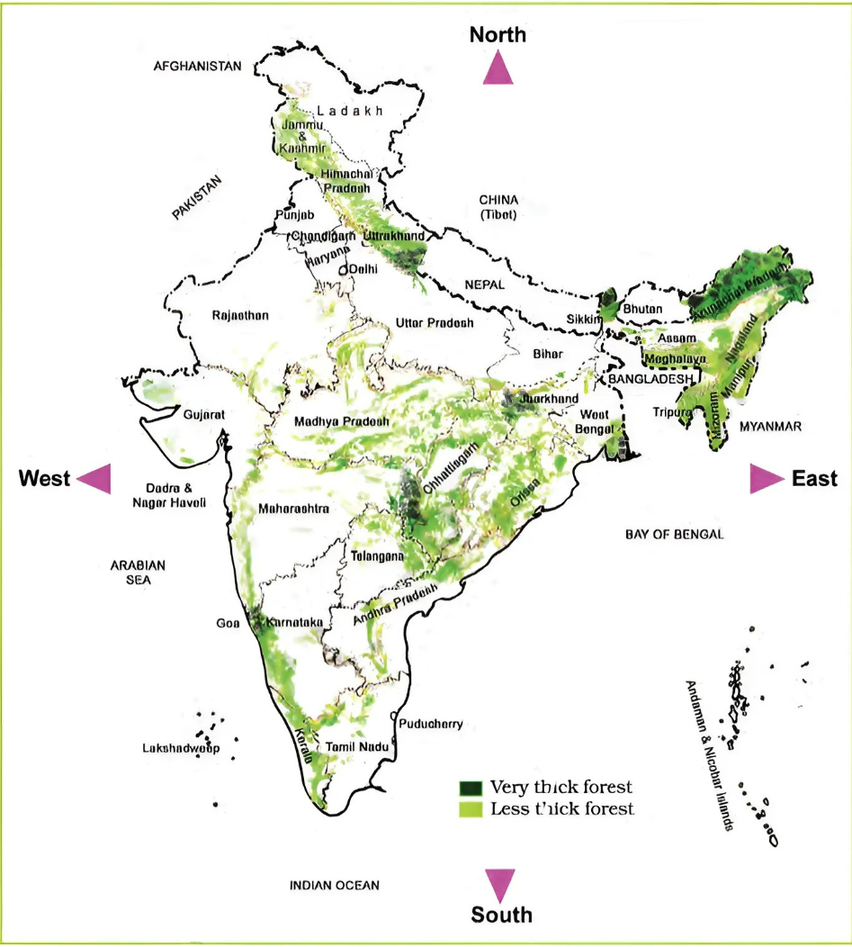 Q1: What all is shown on the map?
Ans:
The map displays various states, major cities, and notable natural landmarks like rivers and mountains across the country.
Q2: Is there a sea close to Orissa? How did you find out?
Ans:
Yes, the Bay of Bengal is next to Orissa. I found this out by looking at the map's geographical features and the labeling of water bodies.
Q3: Which are the states which have the sea on one side?
Ans:
States like Gujarat, Maharashtra, Goa, Karnataka, Kerala, Tamil Nadu, Andhra Pradesh, Odisha, and West Bengal have the sea on one side, offering them beautiful coastlines.
Q4: Where is Suryamani’s state Jharkhand on the map?
Ans:
Jharkhand is located in the eastern part of India, known for its rich forests and mineral resources.
Q5: Where are forests on the map? How will you find these?
Ans:
Forests are indicated in green on the map, showing their spread across various states. You can find them by looking for the green-colored areas.
Q6: How can you find out which states have very thick forests and which have less thick forests?
Ans:
The shade of green on the map helps identify this: darker greens represent thicker forests, while lighter greens indicate less dense forested areas.
Q7: For someone in Madhya Pradesh, in which direction would the country’s thickest forests be? Name those states.
Ans:
For someone in Madhya Pradesh, the thickest forests would be towards the east and northeast, in states like Chhattisgarh, Odisha, Jharkhand, and West Bengal.
Q1: What all is shown on the map?
Ans:
The map displays various states, major cities, and notable natural landmarks like rivers and mountains across the country.
Q2: Is there a sea close to Orissa? How did you find out?
Ans:
Yes, the Bay of Bengal is next to Orissa. I found this out by looking at the map's geographical features and the labeling of water bodies.
Q3: Which are the states which have the sea on one side?
Ans:
States like Gujarat, Maharashtra, Goa, Karnataka, Kerala, Tamil Nadu, Andhra Pradesh, Odisha, and West Bengal have the sea on one side, offering them beautiful coastlines.
Q4: Where is Suryamani’s state Jharkhand on the map?
Ans:
Jharkhand is located in the eastern part of India, known for its rich forests and mineral resources.
Q5: Where are forests on the map? How will you find these?
Ans:
Forests are indicated in green on the map, showing their spread across various states. You can find them by looking for the green-colored areas.
Q6: How can you find out which states have very thick forests and which have less thick forests?
Ans:
The shade of green on the map helps identify this: darker greens represent thicker forests, while lighter greens indicate less dense forested areas.
Q7: For someone in Madhya Pradesh, in which direction would the country’s thickest forests be? Name those states.
Ans:
For someone in Madhya Pradesh, the thickest forests would be towards the east and northeast, in states like Chhattisgarh, Odisha, Jharkhand, and West Bengal.
Find out:
Q1: Which are the states around Mizoram? Ans: Mizoram is surrounded by Tripura, Assam, and Manipur, along with a border with Bangladesh and Myanmar. Q2: Chamui said they measure land using tin. Which are the other ways of measuring land? Ans: Land can be measured using modern units like acres, hectares, or square meters, depending on the country's standard measurement system. Q3: Returning from school, children drank water in a bamboo cup. Who do you think would have made this cup and kept it in the forest? Why? Ans: Local inhabitants or travelers who respect nature and tradition might have made and left the bamboo cups for others to use, promoting a sustainable way of living. Q4: What could be done to save forests? Ans: To save forests, we can do the following things:- Plant more trees in your community or school.
- Use paper wisely and recycle it to save trees.
- Learn about forests and share your knowledge with friends and family.
- Join or support groups that work to protect forests.
- Encourage adults to buy products from companies that help save forests.
- Take part in local clean-up days to keep forests healthy.
Importance of NCERT Solutions for Class 5 EVS Chapter 20
The NCERT solutions for Class 5 EVS Chapter 20, titled "Whole Forests," provide young learners with a vital exploration of forest ecosystems and their crucial role in our world. This chapter uses clear and insightful explanations to teach children about the diversity of life within forests, the significance of these natural habitats to the planet's health, and the urgent need for their preservation. By studying these solutions, students gain a deep appreciation for the interconnectedness of life and the importance of conservation efforts. Whose Forests not only enhances students' knowledge of environmental science but also fosters a sense of responsibility toward protecting our natural world. It demonstrates how forests are more than just collections of trees—they are vibrant ecosystems that support life on Earth. Through this chapter, students are inspired to adopt attitudes and behaviors that contribute to environmental sustainability, promoting a future where humans live in harmony with nature.Benefits of NCERT Solutions for Class 5 EVS Chapter 20
The NCERT Solutions for Class 5 EVS Chapter 20, "Whose Forests," unlocks a wealth of knowledge for students eager to understand the natural world and the importance of forests. Here's how these solutions enhance the educational journey:- Deep Dive into Forest Ecosystems: This chapter opens up a world of learning about the complexity and vitality of forests. The solutions provide comprehensive insights into biodiversity, ecosystem services, and the critical role forests play in sustaining life on Earth.
- Inspires Interest in Environmental Stewardship: Through captivating stories and examples, these solutions ignite students' passion for nature conservation and the significance of preserving forests for future generations. It motivates learners to explore how they can contribute to environmental protection.
- Thorough Exam Preparation: By addressing all key questions from the chapter, these solutions ensure students are well-prepared for exams. They furnish students with the necessary understanding and confidence to tackle related questions effectively.
- Simplifies Complex Environmental Concepts: For students who find the intricate details of ecosystems and conservation challenging, the NCERT Solutions offer straightforward explanations, enhancing their grasp of these essential topics.
- Engages with Practical, Real-world Issues: Incorporating activities that prompt students to think about their relationship with the environment, the solutions connect classroom learning to real-world environmental issues, promoting actionable understanding.
- Meets Educational Objectives: Crafted to the CBSE curriculum for Class 5 EVS, these solutions keep students aligned with academic requirements, facilitating a focused and productive study experience.
NCERT Solutions for Class 5 EVS Chapter 20 FAQs
What are the main topics covered in Chapter 20 "Whose Forests"?
The chapter explores forest ecosystems, their biodiversity, and the importance of forests in maintaining ecological balance.
Why is biodiversity important in forests?
Biodiversity ensures the stability and resilience of forest ecosystems, supporting a wide range of plant and animal life that contributes to the health of our planet.
How do forests benefit humans?
Forests provide essential services like oxygen production, carbon storage, soil preservation, and resources like wood, medicine, and food.
What can students learn about conservation from "Whose Forests"?
Students learn the significance of conserving forests to protect biodiversity, combat climate change, and preserve natural resources for future generations.
Are there any specific activities recommended in the chapter to understand forests better?
Yes, activities include researching local forest types, understanding the roles of various plants and animals in the ecosystem, and projects on conservation efforts.
How does Chapter 20 address the issue of deforestation?
It discusses the causes and impacts of deforestation, highlighting the urgent need for sustainable practices and conservation measures to protect forests.
What role do forests play in combating climate change?
Forests act as carbon sinks, absorbing CO2 from the atmosphere. This helps reduce the effects of climate change, making forest conservation critical.


Join 15 Million students on the app today!

Free Learning Resources
PW Books
Notes (Class 10-12)
PW Study Materials
Notes (Class 6-9)
Ncert Solutions
Govt Exams
Our Other Websites
Class 6th to 12th Online Courses
Govt Job Exams Courses
UPSC Coaching
Defence Exam Coaching
Gate Exam Coaching
Other Exams
Know about Physics Wallah
Physics Wallah is an Indian edtech platform that provides accessible & comprehensive learning experiences to students from Class 6th to postgraduate level. We also provide extensive NCERT solutions, sample paper, NEET, JEE Mains, BITSAT previous year papers & more such resources to students. Physics Wallah also caters to over 3.5 million registered students and over 78 lakh+ Youtube subscribers with 4.8 rating on its app.
We Stand Out because
We provide students with intensive courses with India’s qualified & experienced faculties & mentors. PW strives to make the learning experience comprehensive and accessible for students of all sections of society. We believe in empowering every single student who couldn't dream of a good career in engineering and medical field earlier.
Our Key Focus Areas
Physics Wallah's main focus is to make the learning experience as economical as possible for all students. With our affordable courses like Lakshya, Udaan and Arjuna and many others, we have been able to provide a platform for lakhs of aspirants. From providing Chemistry, Maths, Physics formula to giving e-books of eminent authors like RD Sharma, RS Aggarwal and Lakhmir Singh, PW focuses on every single student's need for preparation.
What Makes Us Different
Physics Wallah strives to develop a comprehensive pedagogical structure for students, where they get a state-of-the-art learning experience with study material and resources. Apart from catering students preparing for JEE Mains and NEET, PW also provides study material for each state board like Uttar Pradesh, Bihar, and others
Copyright © 2026 Physicswallah Limited All rights reserved.