HOW DO WE MAP SPACE AROUND US?
Visualising solid shapes of Class 8
HOW DO WE MAP SPACE AROUND US?
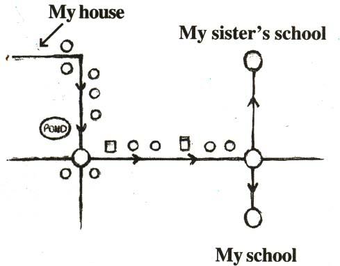
When we draw a picture, we attempt to represent reality as it is seen with all its details, whereas, a map depicts only the location of an object, in relation to other objects. Secondly, different persons can give descriptions of pictures completely different from one another, depending upon the position from which they are look at the house. But, this is not true in the case of a map. The map of the house remains the same irrespective of the position of the observer. In other words, perspective is very important for drawing a picture but it is not relevant for a map.
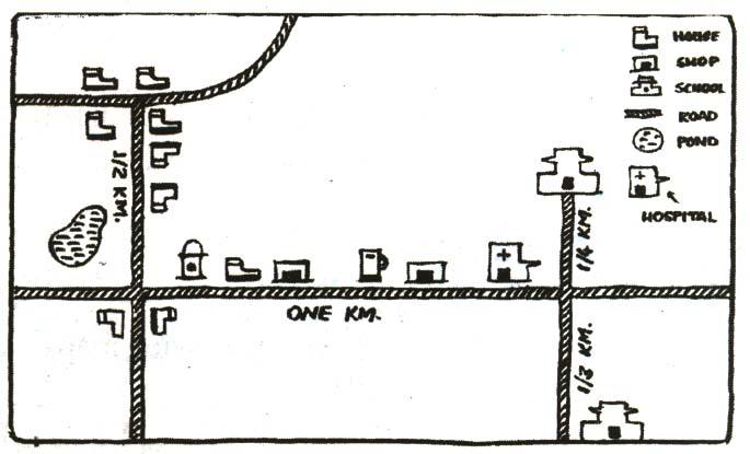
Use of certain symbols and mentioning of distances helps us to read the map easily. Observe that the distances shown on the map are proportional to the actual distances on the ground. This is done by considering a proper scale. While drawing (or reading) a map, knowledge of scale to be drawn (or has been drawn), i,e, how much of actual distance is denoted by 1 mm or 1 cm in the map, should be taken care off. This means, that if one draws a map, he/she has to decide that 1 cm of space in that map shows a certain fixed distance of say 1 km or 10 km.
MAPPING SPACE AROUND US:
When we draw a picture, we attempt to represent reality as it is seen with all its details, whereas, a map depicts only the location of an object, in relation to other objects. Secondly, different persons can give descriptions of pictures completely different from one another, depending upon the position from which they are look at the house. But, this is not true in the case of a map. The map of the house remains the same irrespective of the position of the observer. In other words, perspective is very important for drawing a picture but it is not relevant for a map.
Use of certain symbols and mentioning of distances helps us to read the map easily. Observe that the distances shown on the map are proportional to the actual distances on the ground. This is done by considering a proper scale. While drawing (or reading) a map, knowledge of scale to be drawn (or has been drawn), i,e, how much of actual distance is denoted by 1 mm or 1 cm in the map, should be taken care off. This means, that if one draws a map, he/she has to decide that 1 cm of space in that map shows a certain fixed distance of say 1 km or 10 km.
|
|
|

CBSE NCERT Solutions for Class 8 Maths
class 8 maths NCERT solutions Chapter 1: Rational Numbers
class 8 maths NCERT solutions Chapter 2: Linear Equations in One Variable
class 8 maths NCERT solutions Chapter 3: Understanding Quadrilaterals
class 8 maths NCERT solutions Chapter 4: Practical Geometry
class 8 maths NCERT solutions Chapter 5: Data Handling
class 8 maths NCERT solutions Chapter 6: Square and Square Roots
class 8 maths NCERT solutions Chapter 7: Cube and Cube Roots
class 8 maths NCERT solutions Chapter 8: Comparing Quantities
NCERT Class 8 Maths solution Chapter 9: Algebraic Expressions and Identities
class 8 maths NCERT solutions Chapter 10: Visualizing Solid Shapes
class 8 maths NCERT solutions Chapter 11: Mensuration
class 8 maths NCERT solutions Chapter 12: Exponents and Powers
class 8 maths NCERT solutions Chapter 13: Direct and Inverse Proportions
class 8 maths NCERT solutions Chapter 14: Factorization
class 8 maths NCERT solutions Chapter 15: Introduction to Graphs
class 8 maths NCERT solutions Chapter 16: Playing with Numbers
Notes,worksheet and solved question for Maths class 8
- class 8 maths notes on chapter Liner equation in one variable
- class 8 maths notes on chapter algebric expression
- class 8 maths notes on chapter Mensuration
- class 8 maths notes on chapter Square and square roots
- class 8 maths notes on chapter statistice
- class 8 maths notes on chapter practical Geometry
- class 8 maths notes on chapter commericial maths
- class 8 maths notes on chapter solid shape
- class 8 maths notes on chapter quadrilaterals
- class 8 maths notes on chapter exponents
- class 8 maths notes on chapter factorisation
- class 8 maths notes on chapter inverse proporation
- class 8 maths notes on chapter cube and cube roots
Check your marks in a chapter which you have complited in school from Physics Wallah chapter wise online test just click on the link given below
chapter wise online test for class 8 maths